How to Get to Butrint
From Sarandë
- By Bus: Local buses to Ksamil (15 minutes, 100 LEK), then taxi to Butrint (5km, €5-7).
- By Car: 18km south via SH81. Drive time approximately 20 minutes.
- By Tour: Most Sarandë hotels arrange tours (€15-25 per person including transport and guide).
From Tirana
- By Bus: Take Tirana-Sarandë bus (5-6 hours, 1,500-2,000 LEK), then local transport to site.
- By Car: 280km via Fier and coastal SH8. Drive time approximately 4.5-5 hours.
- By Tour: Multi-day tours typically combine Butrint with Gjirokastër and Blue Eye.
From Corfu, Greece
- By Ferry: Daily ferries Corfu-Sarandë (30-45 minutes, €20-25), then bus or taxi to Butrint.
Note: Site entrance is 1km from parking area along easy walking path through wetlands. Allow 3-4 hours minimum for the archaeological park circuit.
The Layers Beneath the Lagoon
In December 1992, UNESCO designated Butrint National Park as World Heritage Site, recognizing what archaeologists had documented across seven decades of excavation: Albania’s most complete Mediterranean archaeological sequence, where Greek colonists, Roman administrators, Byzantine bishops, Venetian military engineers, and Ottoman governors built their civilizations atop one another’s foundations without destroying what came before.
The designation came with immediate controversy. Five years later, in 1997, UNESCO placed Butrint on its List of World Heritage in Danger due to concerns about looting, lack of protection, and management failures during Albania’s chaotic post-communist transition. The site remained endangered for eight years until 2005, when improved security, systematic conservation efforts, and international archaeological collaborations convinced UNESCO that this extraordinary place could be protected for future generations.
Today, Butrint represents Albania’s premier archaeological destination—not because it preserves one civilization particularly well, but because it preserves all of them remarkably intact. The 4th-century BCE Greek theater still holds limestone seats carved with the names of 150+ freed slaves. The Roman forum’s geometric pavements remain protected under careful soil coverage that shields them from the very humidity that preserved them for 1,600 years. The 6th-century Byzantine baptistery’s eight-ring mosaic floor rivals anything found in Ravenna or Constantinople. The Venetian hilltop castle and triangular waterside fortress demonstrate 500 years of evolving military architecture adapted to the same strategic imperative: controlling ship passage through the narrow Vivari Channel separating Albania from Corfu.
Walking Butrint’s two-kilometer circuit trail through these layered civilizations requires confronting a fundamental question about Mediterranean history: why did successive empires choose to build here, in wetlands where malaria once killed as readily as warfare, where isolation from major trade routes made every supply shipment difficult? The answer lies in understanding how strategic geography, natural harbors, and defensive advantages outweighed every hardship—and how 2,500 years of human adaptation to this landscape created archaeology that tells the Mediterranean’s complete story in concentrated form.
Why Visit Butrint (And Who Should Skip It)
Visit Butrint if you want Albania’s single most comprehensive historical experience, where walking 2 kilometers through wetland forest takes you from 4th-century BCE Greece through 15th-century Venetian military engineering without missing a major Mediterranean civilization. The archaeological preservation rivals anything found in Greece or Italy, the wetland setting creates landscape beauty that purely inland sites cannot match, and the relative isolation from mass tourism (compared to Pompeii, Ephesus, or Delphi) allows contemplation impossible at more famous destinations.
The Greek theater alone justifies the journey. Built into natural hillside in the 4th century BCE and modified by Romans in the 3rd century CE, it represents Albania’s finest surviving example of ancient theatrical architecture. But what makes it extraordinary are the manumission inscriptions—150+ names of freed slaves carved into the limestone seats by Greek citizens who purchased their freedom and wanted the act commemorated in the community’s most public gathering space. These aren’t royal proclamations or priestly dedications. They’re ordinary people documenting their transformation from property to legal persons, witnessed by their entire community in a sanctuary dedicated to Asclepius, god of healing and transformation.
The Roman forum, systematically excavated only since 2005, preserves geometric pavement patterns and architectural foundations under protective soil coverage that allows controlled viewing when lagoon water levels permit safe exposure. This civic center of Roman Buthrotum rivaled provincial forums across the empire—temples, commercial porticos, administrative buildings arranged around public space where citizens conducted the business of empire. The late 4th-century earthquake that buried this complex beneath protective soil created accidental preservation that modern excavators must carefully manage, exposing sections briefly then re-covering them to prevent degradation from humidity and vegetation.
The Byzantine baptistery represents the Mediterranean’s finest early Christian mosaics outside Ravenna. Eight concentric rings surround the central baptismal font—the number associated with salvation and eternal life in Christian numerology—executed in colored stone tesserae creating geometric patterns, symbolic animals (peacocks drinking from vessels of eternal water, representing immortality), and vine scrolls symbolizing Christ as the true vine. The 6th-century craftsmen working here possessed skills rivaling anything produced in Constantinople, applied to a building program that transformed this ancient Greek sanctuary into Christianity’s regional center.
The Venetian and Ottoman fortifications demonstrate how the same strategic imperative—controlling the Vivari Channel between Corfu and mainland—drove military architecture for 500 years. The hilltop Venetian castle, built on Byzantine foundations in the 15th century, provides surveillance across lake, channel, and wetlands. The Triangular Castle below directly controls ship movements through the narrow passage where all maritime traffic between Greece and Albania must pass. These fortifications weren’t protecting ruins; they were controlling active commercial and military routes that remained vital through the Ottoman period and beyond.
Skip Butrint if you need modern infrastructure, expect museum-quality interpretation at every monument, or cannot handle uneven ancient surfaces and limited shade during summer heat. The site offers basic facilities—small cafe, minimal bathrooms, rudimentary site maps—but nothing approaching the visitor infrastructure at major Greek or Italian archaeological parks. The wetland setting means summer brings mosquitoes and humidity that make the experience genuinely uncomfortable without preparation. And the archaeological interpretation assumes visitors arrive with foundational knowledge of Mediterranean history; those expecting every monument to be thoroughly explained will find the minimal signage frustrating.
Also skip Butrint if you’re seeking untouched wilderness or purely natural experience. This is entirely cultural landscape, shaped by 2,500 years of human habitation. The “natural” wetlands exist partly because medieval and later residents abandoned agricultural drainage systems that Romans maintained. The forest growing around monuments represents relatively recent vegetation rather than primeval wilderness. Understanding Butrint requires accepting that nature and culture have intertwined here so completely that separating them becomes artificial exercise.
The honest assessment: Butrint rewards visitors willing to spend 3-4 hours carefully walking the circuit trail, reading the limited but informative signage, and bringing enough historical knowledge to contextualize what they’re seeing. For those meeting these requirements, it delivers Albania’s premier archaeological experience in setting that makes the ancient Mediterranean’s strategic calculus immediately comprehensible.
The Greek Theater and Sanctuary of Transformation
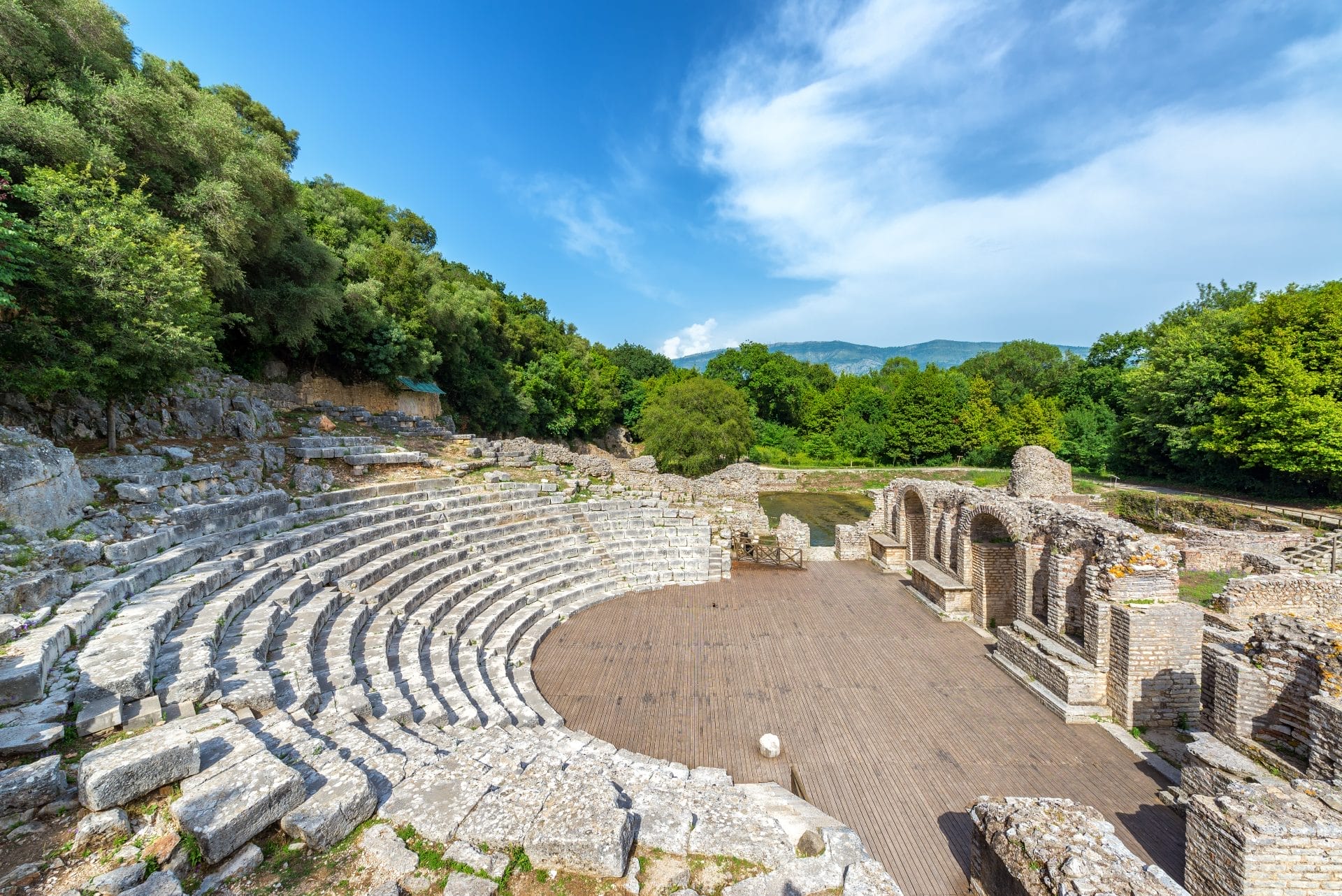
The 4th-century BCE Greek theater, built into natural hillside overlooking what would become the Roman forum, represents Butrint’s earliest substantial architectural evidence and its most immediate connection to ordinary ancient lives through those extraordinary manumission inscriptions.
Luigi Maria Ugolini, the Italian archaeologist who led systematic excavations from 1928-1936, first exposed this theater from centuries of accumulated soil and vegetation. His work revealed a standard Greek theatrical layout—semicircular orchestra for chorus performance, tiered limestone seating (cavea) accommodating approximately 2,500 spectators, and hillside position providing natural acoustics and dramatic backdrop. The Romans later added permanent stone staging (scaenae frons), vaulted passageways (vomitoria) for improved crowd movement, and architectural embellishments reflecting imperial tastes while preserving the essential Greek form.
But the inscriptions transform this theater from typical provincial architecture into something more intimate and immediate. Carved into limestone seats throughout the theater, over 150 manumission declarations record the names of individuals who purchased their freedom, the citizens who freed them, and the god Asclepius in whose sanctuary this freedom was granted. The inscriptions follow formal patterns:
“[Name] dedicated to Asclepius by [owner’s name], witnessed by [official’s name], in the year [date].”
These brief texts document profound personal transformations. In Greek society, manumission represented complete legal metamorphosis from property to person—former slaves gained rights to own property, conduct business, marry legally, and participate (though limitedly) in civic life. That freed individuals chose to commemorate this transformation in theater seats rather than private monuments reveals how public and communal Greek concepts of identity were. Freedom meant nothing unless witnessed and recognized by the entire community gathering for religious festivals and theatrical performances in honor of the gods.
The theater’s connection to the adjacent Sanctuary of Asclepius made it ideal location for these declarations. The god associated with healing also represented transformation more broadly—from sickness to health, from ignorance to knowledge, from slavery to freedom. Greek medicine and Greek philosophy both understood transformation as fundamental human possibility, and Asclepius embodied this principle. The sanctuary drew pilgrims from across Epirus seeking healing through dream incubation—sleeping in sacred space hoping the god would appear in visions offering medical guidance or miraculous cure.
When Ugolini excavated the small sanctuary treasury near the theater in 1929, his team discovered over 300 bronze votive offerings—figurines of body parts (legs, arms, torsos) representing ailments for which pilgrims sought healing, medical instruments, personal tokens, miniature representations of livestock and agricultural tools. These objects documented individual relationships with divine power: physical evidence of prayers offered, healing sought, gratitude expressed for recovery granted.
The sanctuary functioned continuously from at least the 4th century BCE through the Roman period, when the expanding theater gradually encroached on sacred space, converting the treasury into practical storage while healing traditions migrated to new Christian sites. Early Byzantine bishops built their Great Basilica and baptistery nearby, maintaining this location’s association with spiritual and physical transformation while redirecting devotion from Asclepius to Christ.
Standing in the theater today, surrounded by those carved names and looking toward the sanctuary where pilgrims once slept seeking divine visions, the ancient Mediterranean’s fluid boundaries between healing, freedom, religion, and community become immediately tangible. This wasn’t abstract philosophy but practical system for managing transformation—personal, legal, spiritual—using architecture, ritual, and public witness as tools for validating change.
The Roman City: Forum, Administration, and Imperial Ambition
Roman Buthrotum reached its maximum extent and prosperity during the 2nd-3rd centuries CE, when the city functioned as significant commercial center controlling maritime routes between Italy and Greece while serving administrative role in Rome’s Epirus province. The forum, systematically excavated from 2005 onward through Anglo-Albanian collaboration, reveals civic architecture rivaling anything found in provincial Italian cities.
The forum occupied level ground created by earlier Greek terracing, approximately 60 meters square, surrounded by colonnaded porticos providing shade for commercial activities and public gathering. Temple foundations along the forum’s edges reference dedications to Minerva Augustus (goddess of wisdom in her Romanized form), while recovered marble sculptures, architectural fragments, and inscriptions document the civic grandeur Romans expected even in relatively remote provincial centers.
Geometric pavement patterns executed in local limestone and imported marble demonstrate the craftsmanship standards applied to civic spaces where citizens conducted legal business, religious ceremonies, and commercial transactions. The preservation of these pavements under protective soil coverage creates modern conservation challenges—excavators must balance archaeological revelation with long-term protection from the very humidity that preserved these surfaces for 1,600 years since the late 4th-century earthquake that devastated the complex.
The earthquake’s timing proved significant. Occurring during early Christian expansion and coinciding with broader Roman imperial decline, it prompted transformation rather than mere reconstruction. Medieval residents built modest homes among the ruins, recycling Roman stones for their own needs while inadvertently protecting ancient pavements beneath their floors. The forum never recovered its civic function; instead, the bishops’ basilicas and baptistery complex shifted the city’s center toward Christian sacred architecture.
Ongoing excavations continue revealing forum details—most of the complex remains buried, with archaeologists exposing small sections when lagoon levels and humidity conditions permit, then carefully re-covering them to prevent degradation. This conservation approach frustrates visitors expecting completely exposed ruins but protects irreplaceable archaeological evidence for future generations and future technologies that may allow better preservation.
Beyond the forum, Roman Buthrotum spread across both sides of the Vivari Channel, connected by bridges whose foundation piers remain visible in the channel waters. Residential districts, commercial areas, bath complexes, and minor temples occupied the expanding urban footprint as Roman peace (pax Romana) created prosperity that earlier centuries’ constant warfare had prevented. Population estimates suggest 10,000-15,000 inhabitants at Buthrotum’s Roman peak—substantial for this region but modest compared to major Mediterranean commercial centers.
The city’s strategic value lay in controlling the narrow channel separating Corfu from the mainland. All ships traveling Adriatic and Ionian routes between Italy and Greece passed through these waters, creating opportunities for customs revenue, commercial exchange, and maritime surveillance that Romans understood and exploited systematically. The natural harbor offered protected anchorage, the wetlands provided defensive advantages against land-based attack, and the position allowed communication between Italian and Greek provinces essential for imperial administration.
Byzantine Transformation: From Pagan Sanctuary to Episcopal Center
The 6th century brought profound transformation to Butrint as Christianity converted this ancient pagan sanctuary into one of Epirus’s principal episcopal centers. The bishops’ building program demonstrates both the wealth flowing through early Byzantine church networks and the sophisticated theological symbolism encoded in architectural and artistic programs.
The baptistery, Butrint’s most celebrated Byzantine monument, houses mosaic floors executed by craftsmen whose skills rivaled the finest work produced in Ravenna or Constantinople during the same period. The central composition features eight concentric rings surrounding the baptismal font, creating powerful theological statement through number symbolism that early Christian audiences understood immediately.
Eight represented resurrection and eternal life in Christian numerology—Christ rose on the eighth day (the day after Sabbath), making eight the number symbolizing new creation and salvation. Baptism enacted spiritual resurrection, transforming catechumens from their old nature into new creation in Christ. The eight-ring composition made this theological concept visually explicit, using architectural form to communicate doctrine.
The mosaic’s symbolic vocabulary extends throughout the composition. Peacocks drinking from vessels represent immortality and resurrection—early Christians believed peacock flesh didn’t decay, making them symbols of incorruptibility. Vine scrolls reference Jesus’s declaration “I am the true vine,” symbolizing believers’ connection to divine life. Geometric patterns create visual rhythm suggesting cosmic order and divine mathematics underlying creation.
The craftsmanship demonstrates extraordinary technical skill. Thousands of small colored stone and glass tesserae (individual mosaic pieces) create gradations, patterns, and figurative elements requiring both artistic vision and precise execution. The mosaicists worked from detailed cartoons (full-scale preparatory drawings), carefully selecting tesserae for color and size, embedding them in mortar at precise angles to catch light appropriately, and creating durable surfaces that have survived 1,500 years with remarkable preservation.
The companion room adjacent to the main baptistery contains contemporary mosaics with different geometric patterns and preserved inscriptions naming bishops involved in the construction program. These inscriptions document ecclesiastical hierarchy and building patronage, though weathering and damage have made complete readings impossible. Conservation efforts continue attempting to stabilize and preserve these extraordinary artworks, though the wetland setting creates perpetual challenges from humidity, lagoon level fluctuations, and vegetation pressure.
The Great Basilica, built as the bishop’s principal church during the same 6th-century building program, represents one of nine Christian basilicas discovered at Butrint—evidence of the site’s religious importance during Byzantine centuries. The structure follows standard early Byzantine basilica architecture: rectangular plan with nave and side aisles separated by columns, eastern apse for the altar, and atrium entrance courtyard. Walking between the stone piers that replaced original columns (likely recycled during medieval modifications), traces of mosaic floor remain visible beneath later flagstone additions.
The basilica’s scale and position demonstrate Christianity’s triumph over pagan traditions. Built immediately adjacent to the earlier Sanctuary of Asclepius, it literally displaced the healing god’s sacred precinct while maintaining the site’s association with transformation and restoration. Pilgrims who once sought Asclepius’s dream-visions now sought Christian baptism, healing relics, and episcopal blessing—different rituals serving similar human needs through new theological framework.
Byzantine Butrint functioned as regional administrative and religious center through the early medieval period, though declining population, economic contraction, and Slavic invasions gradually diminished the city’s significance. The great earthquake that devastated the Roman forum also damaged Byzantine structures, though the basilicas continued functioning through modifications and repairs. Malaria, endemic in wetland regions before modern mosquito control, likely contributed to population decline as residents abandoned low-lying areas for healthier highland settlements.
Venetian and Ottoman Fortifications: Five Centuries of Strategic Control
The hilltop Venetian castle and the waterside Triangular Castle demonstrate how one strategic imperative—controlling the Vivari Channel between Corfu and the Albanian mainland—drove military architecture across five centuries of Mediterranean power competition.
The hilltop castle occupies the site’s highest elevation, built on Byzantine fortification foundations during the 15th century when Venice controlled Corfu and needed to secure the crucial channel separating that island from hostile Ottoman territories. The elevated position provides surveillance across channel, lake, wetlands, and surrounding landscape, allowing early warning of approaching threats while offering protected position for defensive operations.
Venetian military engineers applied principles developed across their Mediterranean empire: thick walls constructed from local limestone and shale, strategic positioning of artillery emplacements, overlapping fields of fire covering all approach routes, and provision storage for extended siege resistance. The castle wasn’t meant to house large permanent garrison but rather to provide fortified position that small defending force could hold against larger attacking army—economy of force multiplying defensive capabilities through intelligent engineering.
The structure now houses Butrint’s main museum, displaying artifacts spanning the site’s complete archaeological sequence. The museum collection includes Greek pottery, Roman sculptures, Byzantine architectural fragments, and exhibits documenting eight decades of archaeological excavation from Luigi Maria Ugolini’s pioneering 1920s-1930s work through contemporary international collaborations. The castle’s panoramic views across the archaeological park below provide essential context for understanding how different civilizations adapted to this landscape’s possibilities and constraints.
The Triangular Castle, positioned at water level directly controlling the Vivari Channel, represents later Ottoman military innovation adapted to the same strategic function. Its distinctive three-sided design wasn’t architectural experimentation but pragmatic engineering for controlling the narrow waterway where all ship traffic must pass. The thick walls and carefully positioned gun emplacements reflect evolving military technology—firearms and artillery replacing earlier defensive strategies based on archery and hand-to-hand combat.
Ali Pasha of Ioannina strengthened these fortifications in the early 19th century as part of his remarkable (though ultimately unsuccessful) bid for autonomous control of a semi-independent state carved from weakening Ottoman Empire. His modifications demonstrate how even declining empires maintained these strategic positions, recognizing that controlling the Corfu Strait remained valuable regardless of which power held sovereignty.
Standing at these fortifications today, watching modern boats navigate the same channel that carried Byzantine galleys, Venetian war ships, and Ottoman naval vessels, the continuity of strategic geography becomes immediately apparent. Technology changes—sail to steam to diesel—but the fundamental calculus of controlling narrow passages persists across centuries. These castles represent physical manifestation of that enduring logic.
The Wetland Setting: Where Landscape Shapes History
Butrint’s wetland environment shaped human settlement patterns for 2,500 years, creating both opportunities and constraints that every civilization had to navigate. The landscape’s fundamental elements remain recognizable to ancient eyes: Lake Butrint’s reed-lined shores, the Vivari Channel connecting to the Ionian Sea, marshlands and Mediterranean forest creating transitional zones between water and land.
The wetlands support 246 documented bird species, making Butrint significant ornithological site beyond its archaeological importance. Migratory waterfowl use the lagoon as resting point along Adriatic flyway routes connecting European breeding grounds to African wintering territories. Resident species include various herons, egrets, and raptors adapted to wetland hunting. The diversity reflects habitat variety—open water, reed beds, mudflats, forest edges—creating ecological niches supporting different species’ requirements.
The Mediterranean forest surrounding archaeological monuments represents relatively recent growth rather than primeval wilderness. Ancient and medieval residents cleared extensive areas for agriculture, construction materials, and fuel. When population declined during late Byzantine and early Ottoman periods, vegetation reclaimed abandoned agricultural land, creating the forest visitors encounter today. Some individual olive and cypress trees may be centuries old, but the overall forest structure reflects post-abandonment succession rather than continuous forest persistence.
The wetland environment created both defensive advantages and significant health challenges. Malaria, transmitted by mosquitoes breeding in still waters, likely killed more Butrint residents across 2,500 years than all military conflicts combined. Ancient and medieval medical knowledge couldn’t identify the disease’s transmission mechanism, though residents understood that wetland areas produced dangerous fevers during summer months. Elite families maintained highland retreats for summer residence, while poorer residents endured the disease risk as price for their livelihoods.
Romans implemented systematic drainage and water management, reducing (though not eliminating) malaria while expanding agricultural land. These hydraulic engineering projects required constant maintenance—when medieval populations declined and centralized administration collapsed, the drainage systems failed, waters reclaimed low areas, and malaria reasserted its grip. This cycle of hydraulic management and subsequent failure repeated across Mediterranean wetland sites, explaining why so many ancient coastal cities were eventually abandoned despite strategic and economic advantages.
Modern malaria eradication during the mid-20th century, using DDT spraying and mosquito breeding ground elimination, finally broke this ancient pattern. Contemporary Butrint remains wetland environment but without the endemic disease that shaped population patterns for millennia. Summer mosquitoes still present nuisance requiring insect repellent, but they no longer carry the parasites that made these wetlands deadly.
The channel waters offer swimming opportunities where visitors can float in the same currents that brought ships from across the ancient Mediterranean. The water clarity results from the lagoon’s connection to open sea through the Vivari Channel, creating tidal exchange that prevents stagnation while maintaining salinity levels supporting diverse marine life. Summer water temperatures reach 23-25°C, comfortable for extended swimming without wetsuits.
Practical Butrint: Visiting Albania’s Premier Archaeological Site
Butrint lies 18 kilometers south of Saranda, Albania’s principal southern coastal city, and 4 kilometers from Ksamil, the beach resort village that has exploded in tourism development over the past decade. The proximity to both creates logistical convenience—most visitors base themselves in Saranda, make day trips to Butrint, and combine archaeological visits with beach time in Ksamil.
Transportation from Saranda: Regular buses depart Saranda for Butrint (and continuing to Ksamil) throughout the day during tourist season (May-September), approximately hourly from 8 AM to 6 PM. The journey takes 30 minutes, costs 200 lek (~€2), and provides basic public transport option for budget travelers. Return buses run similar schedule, though confirming the last bus time prevents getting stranded (typically 6-7 PM depending on season).
Taxis from Saranda charge 3,000-4,000 lek (~€30-40) for return trip with waiting time at Butrint. This option suits small groups splitting costs or travelers valuing schedule flexibility over budget economy. Rental cars, available from multiple agencies in Saranda from €20-30/day, provide maximum independence for visiting Butrint, Ksamil, the Blue Eye spring, and other southern attractions during multi-day stays.
Entry and Hours: Butrint charges 1,000 lek (~€10) admission for adults, 500 lek for youth aged 12-18, free for children under 12. The site opens daily 8 AM to sunset (approximately 7 PM in summer, 5 PM in winter). The castle museum operates more limited hours, typically 9 AM-7 PM during peak season. Payment is cash only—both Albanian lek and euros accepted, though change may be given in lek. No advance booking required or available; purchase tickets at the entrance gate.
Circuit Trail and Duration: The main archaeological circuit covers approximately 2 kilometers through gentle terrain with some moderate inclines approaching the hilltop castle. Well-maintained gravel and stone paths connect the major monuments: Greek theater → Sanctuary of Asclepius → Roman forum → Great Basilica → Baptistery → hilltop Venetian Castle → Triangular Castle → wetland trails returning to entrance. Allow minimum 3 hours for reasonably thorough visit; 4+ hours permits careful exploration and museum time.
Seasonal Considerations: April through October provides optimal visiting window. Spring (April-May) offers moderate temperatures, blooming vegetation, and migratory bird activity without peak summer crowds. Summer (June-August) brings warmest weather, longest daylight hours, and maximum crowds—the site can feel uncomfortably busy during July-August midday hours, with limited shade making heat management essential. Autumn (September-October) matches spring’s advantages with added benefit of warm water temperatures in the channel for swimming.
Winter visits remain possible but less rewarding—shorter days limit exploration time, some facilities may operate reduced hours or close entirely, and wetland weather creates muddy conditions. The monuments themselves remain accessible year-round, but the overall experience diminishes significantly outside April-October window.
Practical Necessities: Sturdy walking shoes prove essential on uneven ancient surfaces that become treacherous when damp. The limestone paving, stone steps, and gravel paths require footwear providing ankle support and slip resistance—sandals or smooth-soled shoes create genuine injury risk. Sun protection (hat, sunglasses, sunscreen) matters critically during summer given limited shade along the circuit trail. Carry adequate water (1-2 liters per person)—the small on-site cafe provides limited refreshments, but relying on it for hydration proves unwise.
Insect repellent during summer months (June-September) helps manage mosquitoes, though contemporary mosquitoes carry no malaria. The wetland environment creates ideal breeding conditions, making bites inevitable without protection. Camera equipment faces no restrictions, though professional photography may require special permits (verify at entrance if shooting commercial work).
Guided Tours vs. Independent Visits: The site provides basic English signage at major monuments offering historical context and archaeological information. Independent visitors with reasonable Mediterranean history knowledge can navigate and understand the major elements without guide assistance. However, local guides unlock layers of meaning, architectural details, and archaeological stories that signage cannot convey.
Guides can be arranged at the entrance gate (negotiate price, typically €30-40 for 2-3 hour tour for groups up to 6-8 people) or pre-booked through Saranda tour operators. The benefit justifies the cost for visitors seeking deeper understanding beyond basic monument identification. Guides familiar with ongoing archaeological work share recent discoveries and conservation challenges that transform passive sightseeing into active engagement with living archaeological project.
Combined Itineraries: Most visitors combine Butrint with Ksamil beaches (4 kilometers away), creating full-day itinerary balancing cultural intensity with seaside relaxation. Morning Butrint visit (8-11 AM, avoiding midday heat) followed by afternoon beach time in Ksamil provides excellent rhythm. Alternatively, Blue Eye spring (30 kilometers from Saranda) combines with Butrint for full-day cultural-natural program, though this requires private transportation.
Corfu day-trippers arriving via morning ferry (25-30 minute crossing from Corfu to Saranda, €25-35) can visit Butrint and return same day, though the schedule requires discipline—ferry arrival ~10 AM, immediate transport to Butrint, 3-hour visit, return to Saranda by 3 PM for ~4 PM ferry departure. The compressed timeline proves manageable but allows no flexibility for extended exploration or side trips.
Nearby Destinations and Regional Context
Saranda (18km north): Southern Albania’s principal coastal city and tourism hub, with seafront promenade, accommodation ranging from budget hostels to upscale hotels (€30-150/night), restaurants serving Albanian and international cuisine, and services (ATMs, pharmacies, supermarkets) unavailable in smaller destinations. Saranda functions as logical base for exploring regional attractions while providing urban amenities and evening dining/entertainment options.
Ksamil (4km southwest): Albania’s most developed beach resort village, where four small islands offshore create sheltered swimming coves with Caribbean-blue clarity. Development has exploded over the past decade—what was fishing village in 2010 now hosts dozens of hotels, beach clubs, restaurants, and bars catering to Albanian and international tourists. Summer (July-August) brings crowds rivaling any Mediterranean beach resort; shoulder seasons (May-June, September-October) offer better balance of good weather and manageable tourist numbers.
Blue Eye (Syri i Kaltër) (30km northeast of Saranda): Natural spring where underground river surfaces through limestone karst, creating deep blue pool of exceptional clarity. The spring maintains constant 10-12°C temperature year-round, meaning swimming is challenging (though some attempt it). A developed site with parking, cafe, and short walking trails through riverside forest, drawing tour buses during peak season but offering genuine natural beauty despite commercialization.
Gjirokaster (70km northeast): UNESCO World Heritage Ottoman-era mountain city with castle, historic district of distinctive stone houses with slate roofs, and associations with writer Ismail Kadare and dictator Enver Hoxha (both born here). The city provides highland alternative to coastal destinations, with cooler temperatures, preserved architectural heritage, and completely different cultural atmosphere from the beach-focused south.
Lëkurësi Castle (above Saranda): Hilltop Ottoman fortification offering panoramic views across Saranda, Corfu, and the Ionian coast. A working restaurant operates within the castle, making sunset dinner here popular tourist activity (reservations recommended during peak season). The short drive or taxi ride from Saranda (15 minutes, 1,000 lek) rewards with perspectives making coastal geography comprehensible.
The Palimpsest Landscape
Departing Butrint as afternoon light angles across wetlands and ancient stones, the site’s essential character becomes clear: this is palimpsest landscape where each civilization wrote over previous layers while preserving elements of everything that came before.
The Greek theater’s limestone seats still proclaim freed slaves’ names after 2,300 years. The Roman forum’s geometric pavements wait beneath protective soil for technologies that will allow permanent exposure without degradation. The Byzantine baptistery’s mosaics continue communicating theological concepts through symbolic language that transcends linguistic barriers. The Venetian and Ottoman fortifications demonstrate how strategic geography creates imperatives persisting across technological revolutions.
UNESCO’s 1992 designation, briefly endangered but ultimately secured, represents international recognition that this concentration of Mediterranean civilizations deserves protection as world heritage belonging to all humanity rather than merely Albanian national patrimony. The ongoing archaeological work—careful excavation, systematic conservation, controlled exposure of fragile elements—continues revealing details about how classical, early Christian, medieval, and early modern societies adapted to this landscape’s possibilities.
For travelers, Butrint offers Albania’s most complete and comprehensible historical sequence in setting where landscape itself explains strategic decisions spanning 2,500 years. The wetland environment that created both opportunity and challenge remains recognizable, allowing visitors to understand ancient calculus without extensive archaeological training. The concentration of monuments within compact 2-kilometer circuit permits thorough exploration in single visit without the geographic sprawl that makes some archaeological sites overwhelming.
Whether Butrint rewards or frustrates depends entirely on visitor expectations and preparation. Those arriving with basic Mediterranean history knowledge, sturdy shoes, realistic expectations about facilities, and 3-4 hours for careful exploration will find this among Albania’s most satisfying destinations. Those expecting museum-level interpretation, modern infrastructure, or quick superficial encounter will likely leave disappointed.
The site exists in productive tension between preservation and revelation—each excavation exposes new details while creating new conservation challenges, each visitor brings revenue supporting protection while contributing to cumulative wear on ancient surfaces. Managing this tension requires constant calibration, explaining why certain monuments remain covered most of the year, why some areas stay closed to public access, and why conservation sometimes prioritizes long-term preservation over immediate visitor experience.
Standing where Venetian soldiers watched for Ottoman ships, where Byzantine bishops baptized converts, where Roman administrators conducted imperial business, where Greek pilgrims sought Asclepius’s healing visions, the Mediterranean’s layered complexity becomes tangible rather than abstract. This is Albania revealing its position as perpetual crossroads—between East and West, between ancient and modern, between what was and what might have been.
Butrint survived 2,500 years of warfare, earthquake, epidemic disease, political transformation, and abandonment. Whether it survives the coming century of climate change, mass tourism, and Albania’s rapid development depends on decisions being made now about how to balance access with protection, revelation with preservation, economic benefit with archaeological integrity.
For now, the Greek theater still holds those limestone seats carved with freed slaves’ names, the Byzantine mosaics still communicate their theological vision to anyone willing to look carefully, and the wetland landscape still supports bird species following migratory routes older than human settlement. How long these endure depends on choices made by archaeologists, conservators, policymakers, and visitors who recognize that some places hold value beyond immediate economic calculation.