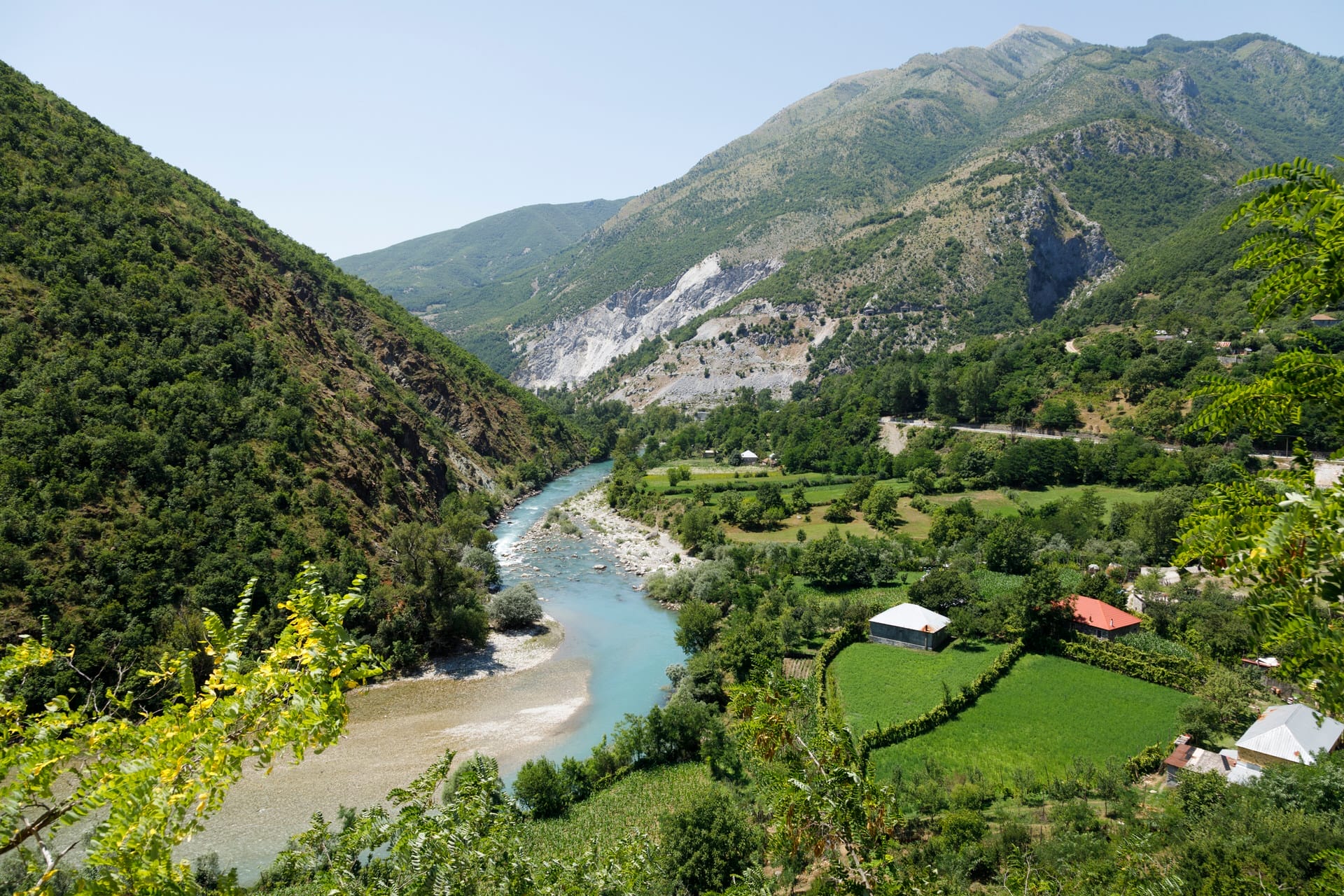
How to Get to Valbona
From Tirana (Via Bajram Curri - Road Route)
- By Bus: Tirana to Bajram Curri (4-5 hours, €10-12), then shared taxi/furgon Bajram Curri to Valbona (1 hour, €5-8 per person). Total: 5-6 hours.
- By Car: 200km via Kukës to Bajram Curri (4-5 hours), then 25km south to Valbona entrance (final section narrow but paved). Total: 5-6 hours.
From Shkodër (Via Lake Koman Ferry - Scenic Route)
- By Ferry Route: Shkodër to Koman (shared transport, depart ~6:30 AM), Lake Koman ferry 9 AM-12 PM (€10, 2.5-3 hours through dramatic flooded gorge), connect to Fierza, then shared taxi Fierza-Valbona (€10-15, 1 hour). Total: 6-7 hours. Ferry operates May-October only.
From Theth
- By Hiking: Valbona-Theth Pass (12-14km, 6-8 hours, 1,795m elevation). No road connection between valleys. Most iconic route but requires moderate-high fitness.
Note: Valbona is remote. Bring cash (no ATMs). Mobile coverage unreliable. Accommodation requires advance booking July-August.
The Valley That Never Surrendered
Valbona Valley exists as geographical anomaly—a fertile glacial valley extending approximately 25 kilometers through the heart of the Albanian Alps (Bjeshkët e Nemuna, “Accursed Mountains”), accessible only via narrow gorge at its northern end where Valbona River exits toward Tropojë. This geographic isolation created natural fortress that northern Albanian mountain clans (the Krasniqi, Gashi, and Kelmendi tribes) defended successfully for centuries against powers seeking to control them.
The Ottoman Empire reached northern Albania in the late 15th century, gradually conquering lowlands and accessible valleys while encountering fierce resistance in mountain regions. The Ottomans established nominal control over Valbona Valley—the area appeared on Ottoman administrative maps, tribute payments were occasionally extracted, and Ottoman authority was theoretically recognized—but practical control remained with local clans governed by the Kanun, the customary law code predating Ottoman arrival and maintaining authority throughout the Ottoman period (1479-1912).
Ottoman officials who attempted to enforce imperial law in Valbona faced armed resistance from clans whose military tradition emphasized guerrilla warfare adapted to mountain terrain. The valley’s geography favored defenders—any force entering through the narrow gorge could be ambushed from heights, and multiple side valleys provided escape routes into even more inaccessible mountains. Ottoman garrison commanders learned that maintaining presence in Valbona required constant military commitment that returned minimal revenue or strategic advantage, creating cost-benefit calculation that favored leaving the valley to its traditional governance.
This de facto autonomy meant Valbona residents maintained traditional social structures, language, Catholic Christianity (alongside some Muslim converts), customary law, and military readiness through centuries when lowland Albania underwent Islamization, Ottoman cultural influence, and integration into imperial administrative systems. The valley functioned as cultural preservation zone where northern Albanian highland traditions survived relatively unchanged from pre-Ottoman period through the end of empire in 1912.
The pattern continued into independent Albania—when King Zog (Ahmed Zogu, ruled 1928-1939) attempted to centralize state authority and disarm mountain clans in the 1920s-1930s, Valbona provided refuge for those resisting. National hero Bajram Curri, who opposed Zog’s authoritarian rule, fled to Valbona in 1925 and died in Dragobi Cave on March 29, 1925, rather than surrender to pursuing government forces. His death in the valley that represented resistance to external authority created symbolic resonance that persists—the nearby town bears his name (Bajram Curri), and the cave remains pilgrimage site for those honoring Albanian independence fighters.
Why Visit Valbona
Valbona attracts travelers seeking Albania’s most dramatic glacial valley scenery accessible without technical mountaineering, the iconic Valbona-Theth Pass hike connecting two wild valleys via high mountain crossing, genuine northern Albanian mountain culture where traditional lifeways persist in functional rather than museum form, historical significance as autonomous region defying Ottoman and later Albanian state control, natural attractions within Valbona Valley National Park including pristine river, waterfalls, and alpine meadows, and authentic guesthouse hospitality where families host travelers in traditional homes.
What Valbona offers: spectacular limestone peaks reaching 2,600+ meters surrounding glacial valley at 1,000 meters elevation, the Valbona-Theth trail (12-14km, 6-8 hours, crossing 1,795m pass) as Albania’s premier day hike, accommodation €20-40 per person including breakfast and dinner in family-run guesthouses, traditional Albanian mountain cuisine including flija (layered pancake cooked under coals), Valbona River offering swimming and fishing in glacier-fed waters, day hikes to Rosuja fortress, Dragobi Cave, and various peaks, and complete disconnection from urban life in valley maintaining traditional rhythms.
What Valbona doesn’t offer: luxury accommodation or modern amenities, restaurants beyond guesthouse meals, shops or services (nearest town Bajram Curri is 25km north), reliable mobile coverage or internet (though some guesthouses have satellite WiFi), easy access (5-6 hour journey from Tirana via rough mountain roads or scenic Lake Koman ferry), activities beyond hiking and cultural immersion, or escape from basic mountain conditions including occasional power outages and shared facilities in budget guesthouses.
Skip Valbona if you prioritize: comfort over authenticity, reliable communications, varied dining options, spontaneous travel without advance planning, destinations accessible to travelers with mobility limitations, or places offering activities beyond hiking and cultural experiences.
Choose Valbona if you value: dramatic alpine scenery in Europe’s last wild mountain valleys, the iconic Valbona Pass hike to Theth, authentic mountain culture where semi-subsistence farming continues, historical significance as autonomous region resisting external control, natural swimming in pristine glacier-fed rivers, traditional guesthouse hospitality, complete digital disconnection, or using Valbona as base for multi-day hiking in Albanian Alps.
The honest assessment: Valbona rewards travelers seeking genuine mountain experience accepting basic conditions, limited services, and isolation from modern conveniences. The valley’s beauty is extraordinary—towering limestone peaks, mixed beech-pine forests, turquoise river, alpine meadows—but appreciating it requires physical fitness for hiking, acceptance of basic accommodations, and interest in mountain culture beyond superficial tourism. Valbona isn’t destination for casual travelers expecting resort amenities or easy access. It’s for serious hikers, cultural anthropology enthusiasts, and travelers specifically seeking places maintaining traditional mountain life in functional rather than performative ways.
Bajram Curri’s Last Stand: Dragobi Cave, March 1925
Bajram Curri (1862-1925) fought for Albanian independence from Ottoman Empire, participated in the 1912 Vlora independence declaration, commanded forces during Balkan Wars and World War I, and emerged as powerful northern Albania leader opposing post-independence attempts at centralized state control. When Ahmed Zogu (later King Zog) began consolidating power in the 1920s, including efforts to disarm mountain clans and impose state authority on traditionally autonomous regions, Curri led armed resistance.
The opposition failed militarily—Zog commanded better-equipped forces supported by Yugoslavia and had successfully neutralized other opposition leaders. By early 1925, Curri fled north into the Albanian Alps seeking refuge among clans whose autonomy he had defended. Zog’s forces pursued, determined to eliminate the symbolic threat Curri represented to centralized state authority.
Curri reached Valbona Valley, where local families provided shelter despite government pressure and threats. When pursuing forces closed in, he retreated to cave above Dragobi village (elevation approximately 1,200 meters, accessible via 2-3 hour hike from valley floor). On March 29, 1925, government troops surrounded the cave. Rather than surrender, Curri died—accounts vary on whether he was killed in firefight, committed suicide to avoid capture, or died from wounds sustained in earlier fighting.
The cave where Curri died remains accessible to hikers willing to make the steep climb from Dragobi village. The site holds no official memorial or interpretation—it’s simply cave in mountainside marked by occasional Albanian flags left by visitors honoring Curri’s resistance. The Albanian government under Enver Hoxha’s communist regime (1944-1991) appropriated Curri as anti-feudal hero fighting against reactionary King Zog, naming the nearby town Bajram Curri in his honor (the town was previously called Kolgecaj). Post-communist reassessments have complicated Curri’s legacy, but he remains significant as symbol of northern Albanian resistance to external authority—whether Ottoman, Yugoslav, or Albanian central government.
For visitors, Dragobi Cave offers both dramatic hike with panoramic valley views and tangible connection to Albanian history at its most contested moment—when independence leaders who had fought together against Ottomans turned weapons on each other over questions of governance, autonomy, and power. The cave’s isolation mirrors Valbona’s broader historical experience of resisting incorporation into centralized authority structures.
Valbona Valley National Park: 8,000 Hectares Since 1996
Valbona Valley National Park received protected status in 1996, covering approximately 8,000 hectares of glacial valleys, forests, alpine meadows, and peaks in the Albanian Alps’ core. The designation aimed to preserve the valley’s natural ecosystems while permitting continued traditional use by local residents who predate conservation measures.
The park protects mixed ecosystems ranging from valley floor (approximately 1,000m elevation) to peaks exceeding 2,600m. Lower elevations support beech forests (Fagus sylvatica) mixed with pine (Pinus nigra), creating dense forest cover where brown bears (Ursus arctos), wolves (Canis lupus), and lynx (Lynx lynx) maintain small populations despite hunting pressures. Mid-elevation meadows host summer grazing for sheep and goats, following traditional transhumance patterns where shepherds move flocks to high pastures June-September. Alpine zones above approximately 1,800m tree line feature specialized flora adapted to harsh conditions—rock jasmine, alpine forget-me-nots, and various endemic Balkan species.
The Valbona River, fed by glacial melt and karst springs, maintains exceptional water quality and clarity. The river supports brown trout populations and provides swimming opportunities in pools where summer temperatures reach 12-16°C—cold but swimmable, unlike the 6-8°C springs found in Theth. Waterfalls occur throughout the valley where tributary streams descend from hanging valleys via vertical drops, with accessible examples near Rrogam and Dragobi villages.
Human habitation within the national park creates management challenges similar to those in Theth—balancing conservation goals with community livelihoods, regulating tourism development, and maintaining traditional practices while protecting ecosystems. Valbona residents maintain customary rights to farm, graze livestock, harvest forest resources, and live in the valley despite national park status. The park administration (theoretically under Albania’s National Agency of Protected Areas) remains understaffed and underfunded, with minimal enforcement capacity for regulations prohibiting illegal hunting, littering, unauthorized construction, or environmental damage.
Tourism has grown substantially since 2010 as the Valbona-Theth trail gained international recognition as Balkans premier day hike. Visitor numbers increased from perhaps 2,000-3,000 annually in early 2000s to estimated 15,000-20,000 by late 2010s. This growth brings revenue supporting guesthouse economy (approximately 30-40 family-run guesthouses operate in the valley) but creates pressures on trails, water resources, waste management (no centralized sewage treatment), and the traditional character attracting visitors.
The Valbona-Theth Pass: Albania’s Premier Mountain Crossing
The hiking trail connecting Valbona to Theth crosses Valbona Pass (Qafa e Valbonës) at 1,795 meters elevation, linking two glacial valleys separated by mountain ridge with no road crossing. The trail covers approximately 12-14 kilometers (measurements vary depending on exact route and whether measured from village centers or trailheads), requiring 6-8 hours for most hikers, with approximately 795 meters elevation gain from Valbona village (1,000m) to pass (1,795m), then 1,015 meters descent to Theth village (780m).
The trail begins at Rrogam, approximately 6 kilometers south of Valbona village proper, accessible by road. From Rrogam, the trail initially follows gentle uphill gradient through mixed forest and meadows, crossing streams via log or stone bridges and passing occasional shepherd’s huts (some operating as seasonal refreshment stands June-September). At approximately 1,300m elevation, the trail steepens, climbing through pine forest thinning toward tree line.
The final approach to Valbona Pass involves rocky switchbacks above tree line where the trail becomes less defined—experienced hikers note that while the general direction remains obvious (upward toward saddle visible between peaks), the exact path varies based on erosion, snowmelt patterns, and route-finding by previous hikers. The pass itself is broad saddle between peaks, marked by seasonal refreshment stand operating June-September (drinks, snacks, simple meals at premium prices reflecting carrying supplies on foot or by pack animal).
From Valbona Pass, the descent into Theth valley provides dramatic views—layers of mountain ridges, Theth valley cutting through peaks below, scattered traditional stone houses. The descent route is steeper than Valbona ascent, following rocky trail through alpine meadows before entering beech forest approximately halfway down, finally reaching Theth village after passing through traditional fields and orchards.
Weather conditions critically affect the hike’s difficulty and safety. July-August offer most reliable weather, though afternoon thunderstorms develop rapidly in mountains—local guides recommend early morning starts (5-6 AM) to reach pass before early afternoon when storms typically form. June sees lingering snow on higher sections and muddy conditions. September brings clear weather and autumn colors but increasing instability as winter approaches. The trail typically operates June-September only; outside this window, snow and weather make crossing dangerous without winter mountaineering equipment and experience.
The one-way nature of the trail creates logistical complications—no road connects Valbona and Theth, requiring travelers to arrange transport returning them to starting point or plan one-way travel continuing via different route. Common solutions include: Lake Koman ferry connecting to/from Valbona combined with bus connections; shared taxi or private transport arranged through guesthouses; or hiking the trail in both directions on separate days (staying overnight at destination).
The trail requires moderate to high fitness level—the elevation gain/loss, rocky terrain, and 6-8 hour duration make this genuine mountain hiking rather than casual walking. Proper hiking boots with ankle support, weather-appropriate clothing including rain gear, sun protection, 2+ liters water (stream sources along route exist but aren’t always reliable), food, first aid supplies, and navigation tools constitute minimum requirements. Hiring local guide (€30-50 arranged through guesthouses) is advisable for hikers unfamiliar with mountain conditions or lacking confidence in route-finding on less-marked trail sections.
Rosuja: Iron Age Fortress in the Unconquered Valley
Rosuja fortress occupies strategic hilltop position approximately 5 kilometers north of Valbona village, accessible via 2-3 hour hike from valley floor. Archaeological excavations (limited in scope due to site’s remoteness and funding constraints) date the fortress to Iron Age (approximately 1000-500 BCE), with evidence of Illyrian tribal occupation during period when these mountains formed border regions between competing Illyrian kingdoms.
The fortress ruins include stone foundation walls, defensive ramparts adapted to natural topography, and evidence of structures suggesting permanent settlement rather than mere military outpost. The site’s elevation (approximately 1,400m) provided commanding views across Valbona valley entrance, allowing occupants to monitor approaching forces and control access to the valley interior.
Excavations recovered coins from ancient Greek colonies of Apollonia and Durrës (ancient Dyrrhachium), indicating trade connections between isolated mountain valleys and coastal urban centers during Hellenistic period (4th-1st centuries BCE). These artifacts demonstrate that Valbona, despite its geographic isolation, participated in broader Adriatic trade networks before Roman conquest disrupted regional patterns.
The fortress apparently continued occupation into Roman period, though evidence suggests reduced importance as Roman road networks created alternative routes bypassing the valley. Medieval and Ottoman period use remains undocumented archaeologically, though local tradition holds that defensive positions existed at Rosuja during Ottoman conflicts.
For contemporary visitors, Rosuja requires commitment—the hike is steep, the site has no facilities or interpretation, and ruins consist primarily of foundation walls requiring imagination to visualize complete structures. However, the combination of archaeological significance (evidence of Illyrian culture in remote mountain setting), panoramic views across Valbona valley, and connection to the valley’s long history of autonomous resistance to external control makes Rosuja worthwhile for travelers interested in Albanian prehistory and willing to invest physical effort accessing remote sites.
Practical Valbona
Getting There: Valbona lies approximately 200 kilometers from Tirana, accessible via two primary routes:
Via Bajram Curri (road): From Tirana, drive northeast via Kukës to Bajram Curri (approximately 4-5 hours on increasingly rough mountain roads), then south 25 kilometers to Valbona valley entrance (final section narrow but paved, requiring careful driving). Total journey 5-6 hours. Buses operate Tirana-Bajram Curri (€10-12, journey 5-6 hours), with occasional shared taxis/furgons Bajram Curri-Valbona (€5-8 per person).
Via Lake Koman ferry (scenic): From Shkodër, shared transport to Koman (departure approximately 6:30 AM), Lake Koman ferry 9 AM-12 PM (€10, 2.5-3 hours through dramatic flooded gorge), connect to Fierza, then shared taxi Fierza-Valbona (€10-15 per person, 1 hour). Total journey 6-7 hours but scenically spectacular. Ferry operates May-October only; outside this window, use road route via Bajram Curri.
Accommodation: Family-run guesthouses provide accommodation €20-40 per person including breakfast and dinner (half-board), with shared or private rooms depending on property. Facilities range from basic (shared bathroom, intermittent electricity, no heating) to modest comfort (private bathroom, more reliable power, WiFi via satellite). The valley hosts approximately 30-40 guesthouses, with concentration in Valbona village, Rrogam (near Theth trail trailhead), and Dragobi.
July-August requires advance booking; June and September see better availability. October-May, many guesthouses close entirely as valley becomes inaccessible or economically unsustainable for hosting minimal winter visitors.
Traditional meals included in guesthouse rates feature mountain cheese, bread, vegetables from household gardens, lamb or goat, flija (layered pancake requiring 2+ hours cooking under coals), cornmeal preparations, and raki (fruit brandy). Meals are communal, eaten with host family and other guests.
Activities: The Valbona-Theth Pass crossing (6-8 hours) dominates most visitors’ itineraries. Additional day hikes include Rosuja fortress (2-3 hours), Dragobi Cave (2-3 hours steep climb), Qafa e Rosit pass (longer full-day hike, less frequented), and various valley exploration trails. Swimming in Valbona River is possible June-September, with water temperature 12-16°C (cold but swimmable).
No services exist beyond guesthouses—no shops, no restaurants, no medical facilities, no ATMs, no reliable mobile network coverage (occasional weak signal, some guesthouses have satellite WiFi). Bring cash, supplies, medications, and anything else you might need from Bajram Curri or Shkodër.
Timing: June-September constitutes the practical visiting window. Lake Koman ferry operates May-October, though May and October see limited guesthouse availability and possible trail closures by snow. Peak season (July-August) brings most crowded conditions, highest prices, and most reliable weather. June offers wildflowers and fewer hikers but possible snow on higher trails. September provides ideal conditions—stable weather, warm temperatures, autumn colors, moderate crowds.
Money and Logistics: Budget €30-50 daily including guesthouse half-board, guide services if hiring for hikes, and incidentals. Bring sufficient cash from Bajram Curri or Shkodër—no banking services exist in Valbona valley. Mobile phones work unreliably; don’t depend on phones for emergency communication or navigation. Offline maps essential.
Nearby Destinations
Theth (12km over mountain pass, no road connection): Glacial valley on western side of Albanian Alps with similar mountain scenery, blood feud towers, and Blue Eye spring.
Bajram Curri (25km north): Town named for national hero, serving as practical base for provisioning before Valbona visit and access point for valley.
Lake Koman Ferry: Departing from Koman (accessible from Shkodër), 2.5-3 hour journey through flooded canyon with fjord-like scenery, often combined with Valbona-Theth hiking in multi-day circuit.
Shkodër (accessible via Lake Koman ferry): Northern Albania’s intellectual capital providing urban amenities, provisioning, and ferry access to Valbona valley.
Tropojë region: Surrounding mountains and valleys offering even more remote hiking, traditional villages, and areas maintaining customs similar to Valbona.
The Unconquered Valley
Valbona’s significance rests on what didn’t happen here—four centuries of Ottoman rule failed to eliminate traditional governance, centralized Albanian state authority failed to disarm mountain clans, and modernization has failed (so far) to completely transform traditional mountain culture into tourism product. The valley exists as living continuation of northern Albanian highland traditions that survived through adaptation, resistance, and geographic isolation creating natural fortress.
Whether this continuation persists depends on economic and political forces beyond local control—tourism revenue enables families to remain in valley rather than emigrating to cities or abroad, but increasing visitor numbers threaten the traditional character attracting those visitors. National park designation provides legal protection but lacks enforcement capacity. Infrastructure development (improved roads, reliable electricity, mobile coverage) makes valley more accessible but also more integrated into national and international systems that historically couldn’t reach here.
For travelers, Valbona offers rare opportunity to experience mountain valley where history of resistance remains tangible—in Dragobi Cave where Bajram Curri chose death over surrender, in Rosuja fortress where Illyrians watched for approaching armies, in stone houses built to withstand siege, and in families maintaining farming and herding traditions while hosting guests in traditional mountain hospitality. This isn’t museum presentation of how people once lived—it’s working community adapting to tourism economy while maintaining practices rooted in centuries of autonomous life.
Whether Valbona satisfies depends on what you seek in destinations. If you need comfort, easy access, varied services, or experiences packaged for convenient consumption, Valbona disappoints. If you value dramatic mountain scenery, authentic culture maintaining traditional lifeways, challenging hiking, historical significance as place that defied empires, and willingness to accept basic conditions as part of genuine experience, Valbona delivers something increasingly rare—a place that remains itself despite pressures to become something more commercially viable but less authentically rooted in place and history.
The limestone peaks still tower above the glacial valley. The Valbona River still flows glacier-cold and turquoise through the valley floor. Families still cook flija using techniques their grandmothers taught them. Shepherds still move flocks to summer pastures following transhumance patterns older than Albanian state. And the Valbona-Theth trail still crosses the pass where hikers walk through landscape that refused to surrender, carrying forward through their footsteps the story of valley that valued autonomy enough to fight for it across centuries.