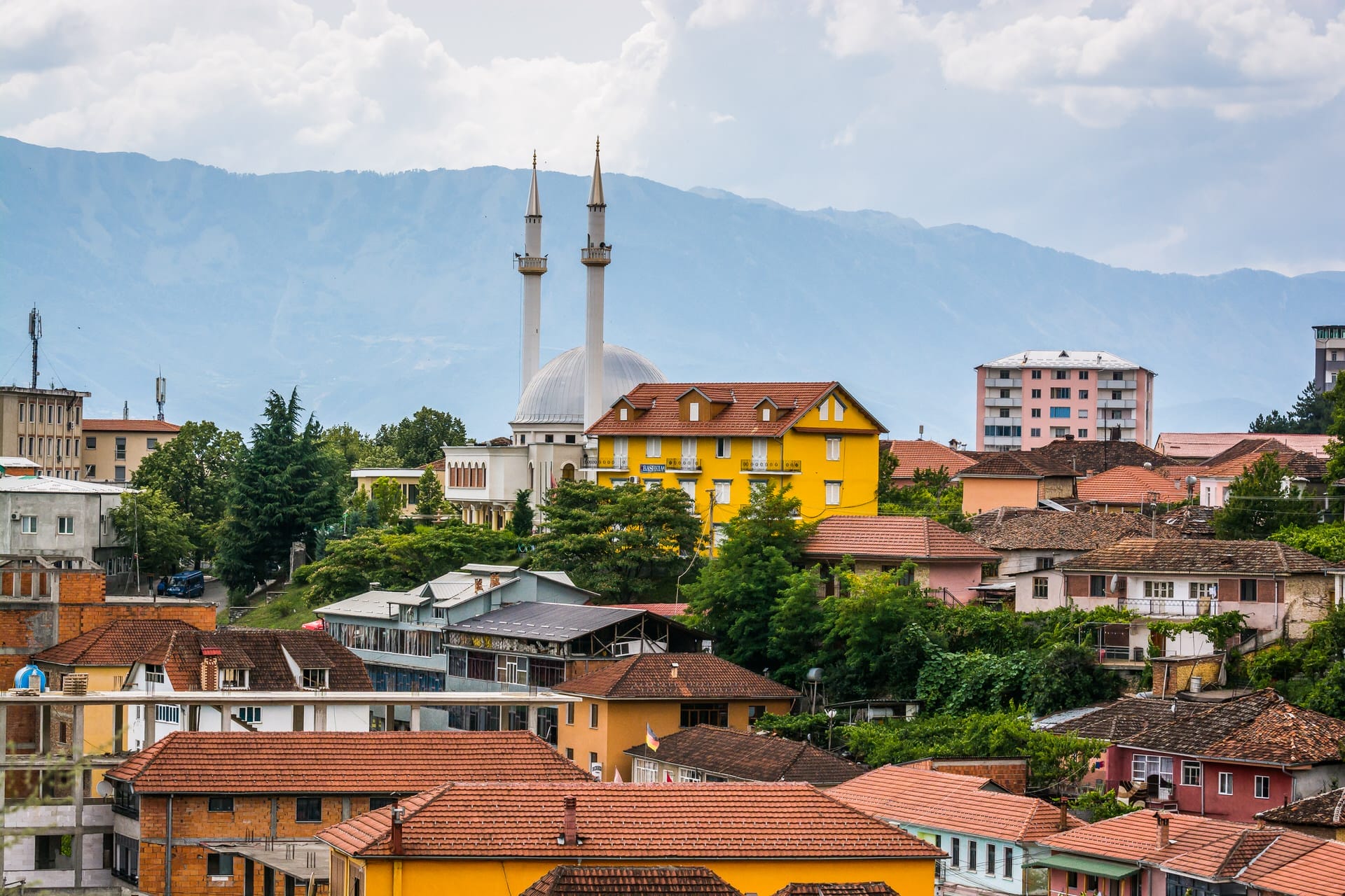
Albania’s Highest Peak and the Valleys Below
Mount Korab rises 2,764 meters on the Albania-North Macedonia border, approximately 40 kilometers east of Peshkopi. The summit marks Albania’s highest point, though the peak itself sits directly on the international boundary—technically, the highest point entirely within Albanian territory is nearby Peak of Korab (Maja e Korabit) at 2,751 meters, though the distinction is largely semantic for climbers accessing both peaks on the same expedition.
The mountain forms part of the Korab-Koritnik massif, a limestone range extending along the border and creating the watershed divide between Adriatic and Aegean drainage basins. Rivers flowing west from these mountains (including the Drini i Zi passing through Peshkopi) eventually reach the Adriatic Sea via the Drin River system. Rivers flowing east drain toward Lake Ohrid and ultimately the Aegean.
Peshkopi, population approximately 14,000, serves as Dibër region’s administrative capital and the primary base for climbers attempting Korab. The town sits at 650 meters elevation in the Drini i Zi valley, positioned where the river valley widens after exiting narrow gorges upstream. This geographic position made Peshkopi a regional center—controlling valley access and trade routes between Albanian lowlands and mountain regions extending toward North Macedonia.
The town’s history reflects standard Albanian mountain town patterns: Ottoman administration from the 15th century through 1912 independence, Italian occupation during World War II (1939-1943), German occupation (1943-1944), and communist period (1944-1991) when the region’s strategic border position resulted in heavy militarization. Post-1991, economic collapse and emigration reduced population as younger residents left for Tirana, Greece, or Italy seeking employment.
Today’s Peshkopi functions primarily as agricultural service town for surrounding mountain valleys, with minimal tourism infrastructure—a few small hotels, basic restaurants, and limited services. The town attracts almost no foreign tourists except mountaineers climbing Korab and occasional adventure travelers exploring northeastern Albania. This isolation creates both the appeal (genuine mountain town life without tourism modification) and the limitation (minimal services, few English speakers, activities requiring self-organization).
Why Visit Peshkopi
Peshkopi attracts specific traveler types: mountaineers climbing Albania’s highest peak, hikers exploring Shebenik-Jabllanicë National Park, travelers interested in Albania’s most isolated and least-visited regions, and people seeking authentic mountain town experience completely outside tourism circuits.
What Peshkopi offers: access to Mount Korab (2-day expedition requiring guide, €100-150 total cost including transportation and guide service), hiking in genuinely wild mountain terrain with minimal infrastructure, experience of northeastern Albanian culture with strong local dialects and traditions differing from coastal or southern Albania, prices reflecting local economy rather than tourism (meals €3-8, guesthouses €15-25/night), and complete absence of foreign tourist presence creating authentic environment.
What Peshkopi doesn’t offer: comfortable infrastructure (accommodation is basic, restaurants serve only Albanian food, no tourism facilities), English language services (virtually no one speaks English outside occasional younger people), easy spontaneous travel (activities require advance arrangement through local guides), or attractions beyond nature and cultural observation (no museums, no historical sites of major significance, no organized activities).
Skip Peshkopi if you prioritize: comfort and convenience, ability to communicate in English, organized tourism activities with established infrastructure, sightseeing attractions beyond natural landscapes, or destinations offering variety beyond hiking and mountain villages.
Choose Peshkopi if you value: climbing Albania’s highest peak, exploring genuinely isolated regions rarely visited by foreigners, experiencing Albanian mountain culture without tourism influence, challenging hiking in wild terrain, and extreme budget travel (this is one of Albania’s cheapest destinations for accommodation and food).
The honest assessment: Peshkopi rewards travelers comfortable with isolation, basic conditions, and self-sufficiency. The town has no compelling attractions beyond serving as Korab base and providing window into northeastern Albanian life. Mount Korab itself is the draw—a challenging but achievable 2-day climb reaching Albania’s literal high point. The surrounding region offers remote hiking, but requires mountain skills, physical fitness, and acceptance of minimal trail marking and services. This isn’t destination for casual travelers or those needing comfort. It’s for mountaineers, serious hikers, and travelers specifically interested in Albania’s most isolated regions.
Mount Korab: The 2-Day Ascent
Climbing Mount Korab from Peshkopi requires two days minimum—one day ascending to mountain hut or camping spot near summit, overnight at altitude, and second day summiting then descending. Attempting the climb in single day is theoretically possible but extremely demanding and not recommended.
Day 1: Peshkopi to Korab Hut - The approach begins with 4WD vehicle transportation from Peshkopi to the village of Radomirë (approximately 1 hour on unpaved mountain roads), then to the trailhead at Shishtavec (approximately 1,200 meters elevation). From there, the trail climbs steeply through mixed forest (beech, fir) for approximately 4-5 hours, gaining 1,000+ meters elevation to reach the Korab mountain hut at approximately 2,200 meters (exact elevation varies depending on which structure you’re counting—several shepherds’ shelters exist at different elevations).
The hut is basic—stone and wood construction, no facilities beyond shelter, no water source immediately adjacent (must be carried from streams encountered during ascent or melted snow depending on season). Most climbers bring camping equipment as backup since hut occupancy can’t be guaranteed, and weather may make the enclosed space preferable to tent camping at altitude.
Day 2: Summit and Descent - Pre-dawn start (typically 4-5 AM) allows reaching summit for sunrise, with approximately 3-4 hours ascent from hut through progressively steeper terrain transitioning from forest to alpine meadow to exposed rock near summit. The final 500 meters involves scrambling over limestone (no technical climbing required but exposure exists) to reach the summit ridge and the border marker precisely on the watershed divide.
Summit views (weather permitting—frequently cloudy) extend across North Macedonia to Lake Ohrid (visible approximately 50km southeast), across Albanian mountains toward the Adriatic (visible on exceptionally clear days 80+ kilometers west), and across the Korab-Koritnik massif stretching northeast along the border. The descent retraces the ascent route, requiring approximately 2-3 hours from summit to hut, then 3-4 hours hut to trailhead, with vehicle transport returning to Peshkopi.
Logistics and Requirements - Guides are essential unless you possess extensive mountain navigation experience and Albanian/Macedonian language skills for interacting with shepherds and border police (who patrol the summit area). Local guides from Peshkopi charge €80-120 for 2-day expedition including vehicle transport to trailhead, guiding service, and assistance with camping/cooking. Guides do not provide equipment—climbers must bring tents, sleeping bags rated for near-freezing temperatures (even in summer nights at 2,200+ meters can drop to 0-5°C), food, water (2-3 liters per person per day), and appropriate mountain clothing and footwear.
The climb itself is Class 1-2 scrambling—no ropes required, but proper hiking boots essential, and trekking poles recommended for steep descents. Physical fitness requirements are moderate to high—expect 7-8 hours hiking per day with 1,500+ meter elevation gain on Day 1, carrying 10-15kg pack. The altitude (2,764m) is low enough that altitude sickness is rare, but acclimatization helps—spending a night in Peshkopi (650m) before ascending reduces risk.
Weather is unpredictable—summer (June-September) offers most stable conditions, but afternoon thunderstorms are common. Winter (November-May) brings heavy snow making the climb dangerous without winter mountaineering equipment. The climbing season effectively runs late June through September, with July-August seeing warmest conditions but also most crowded (though “crowded” means perhaps 5-10 people per day attempting the climb, not masses—this isn’t a popular international destination).
Border considerations: The summit sits on the international boundary, but climbers approach from Albanian side and typically don’t cross into North Macedonia. However, border police patrol the area, and carrying passport is mandatory. Do not attempt to descend the Macedonian side without proper documentation and permissions.
Shebenik-Jabllanicë National Park: Eastern Albania’s Wild Forests
Approximately 35 kilometers south of Peshkopi, Shebenik-Jabllanicë National Park protects 34,000 hectares of mixed mountain forests spanning the border with North Macedonia. Established 2008, the park encompasses elevation range from 300 meters in valley bottoms to 2,262 meters on Mount Shebenik’s summit, protecting diverse ecosystems including Balkan beech forests, mixed conifer stands, alpine meadows, and several glacial lakes.
The park is genuinely wild—minimal infrastructure, no visitor centers, limited trail marking, and no facilities beyond what exists in access villages. This lack of development reflects both Albanian park management’s limited resources and the park’s remote location far from tourism concentrations. The result is authentic wilderness experience requiring self-sufficiency and mountain skills.
Access points include:
- Lura village (accessible from Peshkopi via unpaved road, approximately 2 hours): Gateway to Lurë region with several glacial lakes (Liqeni i Lures, elevation 1,400m) offering day hikes through beech forests and alpine scenery. Lura maintains small guesthouse and basic services.
- Ostren village: Southern access point with trails to Mount Shebenik (2,262m), requiring 2-day expedition similar to Korab logistics.
- Jabllanicë: Eastern sector with cross-border trails connecting to North Macedonia (border crossing restricted, passport required).
Wildlife includes brown bear (Ursus arctos), wolf (Canis lupus), Balkan lynx (Lynx lynx balcanicus—critically endangered subspecies with perhaps 30-50 individuals remaining in wild, primarily in Albania-North Macedonia border regions), Balkan chamois (Rupicapra rupicapra balcanica), golden eagle (Aquila chrysaetos), and various endemic Balkan insects and amphibians.
The park’s glacial lakes formed during Pleistocene glaciation (ending approximately 12,000 years ago) when mountain glaciers carved cirques that later filled with water as climate warmed. These lakes—cold, oligotrophic (low nutrient), and surrounded by old-growth forests—represent rare ecosystems in Balkans where most mountain lakes have been modified by human activity.
Visiting Shebenik-Jabllanicë requires: private vehicle (roads are unpaved and challenging), camping equipment (minimal accommodation exists in access villages), food and water self-sufficiency, map and compass or GPS (trails are poorly marked), and realistic assessment of hiking skills and fitness. This is not destination for casual day-trippers—plan multi-day expeditions with proper equipment and preparation.
The Drini i Zi Valley and Mountain Villages
The Drini i Zi (Black Drin) River originates at Lake Ohrid’s northern end, flowing through North Macedonia before entering Albania near Peshkopi. The river’s name derives from dark coloration caused by dissolved organic matter from forest watersheds—though calling it “black” is poetic exaggeration; the water appears dark green or brown depending on light and flow conditions.
The river valley served historically as trade route connecting Lake Ohrid region to Albanian lowlands, with Peshkopi controlling the strategic position where the valley widens. Ottoman-era stone bridges survive at several points along the valley, though most are in deteriorating condition after decades without maintenance.
Mountain villages scattered across valleys feeding the Drini i Zi maintain traditional alpine economy patterns—sheep and goat herding on high pastures during summer (transhumance), subsistence agriculture in valley bottoms (potatoes, corn, vegetables), chestnut and walnut collection from forest groves, and limited cash income from remittances sent by family members working elsewhere. Population decline since 1991 left many villages with primarily elderly residents as young people emigrated seeking employment.
The architecture reflects mountain adaptation—stone first floors providing thermal mass and protection from winter conditions, wooden upper floors (lighter and more flexible during earthquakes), steeply pitched roofs shedding heavy snow, and small windows minimizing heat loss. Many houses date to 19th or early 20th century, built during Ottoman period using techniques unchanged for centuries.
Communist-era relics appear throughout the region—concrete bunkers (Enver Hoxha’s paranoid defensive structures) scattered across hillsides, abandoned collective farm buildings, and occasional rusting agricultural equipment. The border areas were heavily militarized during the communist period (1944-1991) due to ideological conflict between Albania and Yugoslavia (which controlled what’s now North Macedonia), leaving landscapes marked by military infrastructure gradually being reclaimed by vegetation.
For travelers, these villages offer glimpse into Albanian mountain life largely unchanged by post-1991 modernization that transformed coastal and urban areas. Homestays can sometimes be arranged through guesthouse contacts in Peshkopi—accommodations will be basic (shared rooms, pit toilets, cold water), meals will be simple mountain fare (dairy products, bread, vegetables, occasionally meat), and communication will be limited (older villagers speak Albanian and perhaps some Macedonian, rarely any English). The experience is ethnographic rather than touristic—you’re observing authentic life, not consuming prepared tourism product.
Practical Peshkopi
Getting There: Peshkopi lies 150 kilometers northeast of Tirana, requiring 2.5-3 hours by car via generally good roads through Burrel and Peshkopia Pass. Daily buses operate Tirana-Peshkopi route (600-800 lek, journey 3-3.5 hours) departing from Tirana’s northern bus terminal. The bus service is reliable but basic—old vehicles, no amenities, frequent stops in villages along the route.
Travelers planning to climb Korab or visit Shebenik-Jabllanicë should rent vehicles in Tirana (€35-50 per day) as accessing trailheads requires 4WD capability and unpaved road navigation that public transport doesn’t serve.
Accommodation: Options are limited to a few basic hotels (€20-30/night for double room with private bathroom) and guesthouses (€15-25/night, sometimes shared bathroom). Facilities are simple—clean rooms, functional plumbing, no luxury amenities, minimal English from staff. Book ahead if visiting during climbing season (July-August) as the limited beds can fill, though “full” means perhaps 20-30 climbers total in town, not mass tourism crowds.
Dining: Restaurants serve standard Albanian mountain fare—grilled meats (lamb, beef, chicken), vegetables (peppers, eggplant, beans), dairy (white cheese, yogurt), bread, and simple pastas. Meals cost €3-8 per person including drink. Albanian wine and raki available. No international cuisine, no menu translations, no adaptation to foreign palates—you eat what locals eat, prepared how locals prepare it.
Guides and Logistics: Climbing Korab or exploring Shebenik-Jabllanicë requires arranging guides through hotel contacts in Peshkopi. Upon arrival, ask hotel staff to connect you with mountain guides—several locals offer services, though none operate formal businesses with websites or online booking. Guides speak Albanian and perhaps some Italian or Greek, rarely English. Communication requires patience, translation apps, or basic shared language skills.
Expect to pay €80-120 total for 2-day Korab expedition including guide service and vehicle transport to trailhead. You must provide your own equipment (tent, sleeping bag, food, water, appropriate clothing and boots). Guides provide route-finding, local knowledge, and assistance with logistics but are not technical mountaineering instructors—they assume you have basic mountain skills.
Timing: Climbing season runs late June through September. July-August offers warmest conditions and most stable weather, though afternoon thunderstorms remain common. September brings cooler temperatures and changing weather patterns but fewer climbers. Winter (November-May) makes Korab dangerous without winter mountaineering equipment; Peshkopi itself experiences harsh winters (temperatures regularly below freezing, significant snowfall) making access difficult and services limited.
Money: ATMs exist in Peshkopi town center, though withdrawing cash in Tirana before arriving provides backup. All transactions are cash (Albanian lek)—no credit cards accepted. Budget €25-35 per person daily including accommodation, meals, and local transport. Korab guide services are additional (€80-120 for 2-day expedition).
Nearby Destinations
Kukës (90km north): Regional center with reservoir, positioned between Peshkopi and Kosovo border, offering slightly better services while maintaining northeastern Albania’s isolated character.
Korçë (100km south): Southeastern Albania’s cultural capital with museums, restaurants, and urban comforts providing contrast after Peshkopi’s mountain isolation.
Lin and Lake Ohrid (80km east): Village on Albanian shore of Lake Ohrid with 8,500-year-old underwater Neolithic settlement and Byzantine basilica, accessible via mountain roads connecting Peshkopi region to lake.
Valbona (120km northwest): Albanian Alps valley with dramatic mountain scenery and established hiking infrastructure, contrasting with Peshkopi’s minimal tourism development.
The Edge of Albanian Tourism
Peshkopi exists at Albanian tourism’s extreme periphery. The town receives perhaps 200-300 foreign visitors annually (mostly Korab climbers), compared to tens of thousands visiting coastal destinations or Berat/Gjirokastër. This isolation creates destination unsuited for most travelers but valuable for specific niches.
Mount Korab’s appeal is straightforward—it’s Albania’s highest point, a clear mountaineering objective requiring moderate technical skills and good fitness. The 2-day expedition offers genuine mountain experience in region seeing minimal climbing traffic, creating solitude rare on popular European peaks. The summit’s position on international border adds geopolitical dimension—you’re standing precisely on the line separating two countries, looking across landscapes shaped by Ottoman rule, Yugoslav socialism, Albanian communism, and post-1991 transition.
The surrounding region—the Drini i Zi valley, Shebenik-Jabllanicë National Park, the scattered mountain villages—rewards travelers interested in landscapes and cultures outside tourism’s influence. This isn’t picturesque preservation for tourists; it’s working landscape where people maintain traditional patterns because alternatives haven’t yet arrived. Whether that situation represents cultural preservation or economic stagnation depends on perspective, but for travelers seeking authentic experience of Albanian mountain life, few destinations are more genuine than Peshkopi and its valleys.
The limitations are real: minimal infrastructure, language barriers, limited services, activities requiring significant self-organization and physical fitness. Comfortable tourism this is not. But for mountaineers climbing Albania’s highest peak, hikers exploring genuinely wild terrain, or travelers specifically interested in northeastern Albania’s isolated regions, Peshkopi provides access and authenticity that no developed destination can match.
The town itself won’t occupy much of your attention—walk the main street in 15 minutes, see everything of interest in an hour. But as base for reaching Albania’s literal high point and exploring the remote valleys and forests surrounding it, Peshkopi serves essential function for travelers whose interests extend vertically toward the 2,764-meter summit where Albania reaches its geographic apex.