Caesar’s Fleet in an Albanian Bay
In January 48 BCE, Julius Caesar stood on the shore of Brundisium (modern Brindisi, Italy) facing a strategic dilemma. His civil war with Pompey Magnus had reached a critical phase. Pompey controlled the eastern Mediterranean with a superior fleet of approximately 300 warships, while Caesar commanded seven legions but only enough transport vessels to move about half his army across the Adriatic in a single crossing. The risk was enormous—if Pompey’s fleet intercepted the transports mid-crossing, Caesar’s forces would be destroyed and the civil war lost.
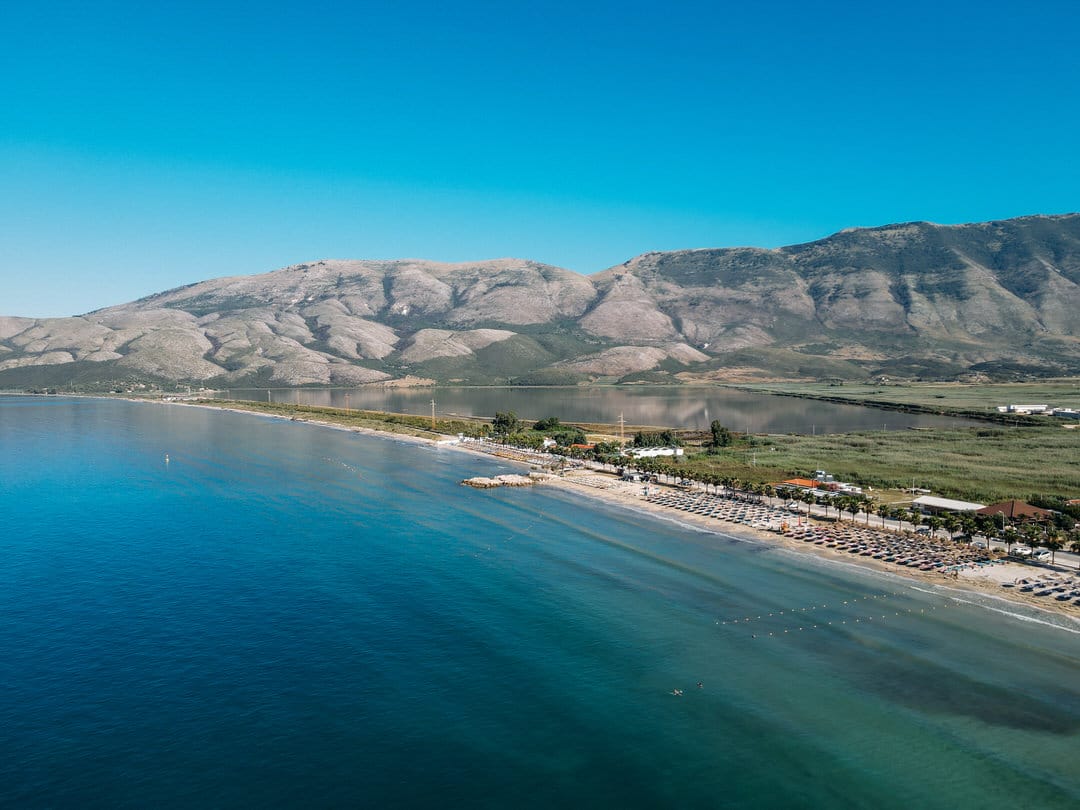
Caesar embarked his troops anyway, sailing through winter storms and arriving on the Albanian coast at the natural harbor of Oricum (modern Orikum) on January 4, 48 BCE. The town’s defenders, part of Pompey’s network, surrendered without resistance when Caesar’s legions appeared. Within hours, Caesar controlled the harbor and had established his Adriatic naval base in one of the most strategically valuable positions on the Illyrian coast—the protected bay where the Adriatic meets what would later be called the Strait of Otranto, commanding the shortest crossing between Italy and Greece.
The ancient settlement Caesar captured that January morning had already stood for approximately 550 years. Greek colonists from Corinth and Corcyra (modern Corfu) had founded Oricum around 625 BCE, recognizing the site’s natural advantages: a deep harbor protected from storms, fresh water from mountain springs, and commanding views across the approaches from both north and south. When Caesar landed, he was securing a harbor that had served Mediterranean maritime networks for over half a millennium—and would continue serving them for two millennia more.
Today’s Orikum sits on the same bay, its approximately 5,000 residents living above and beside the ruins of the ancient city. The archaeological remains are modest—partial walls, foundation outlines, fragments of what once stood here—but the strategic position Caesar recognized remains unchanged. The bay still offers natural protection, the mountains still rise to the east, and the strait connecting the Adriatic to the Ionian Sea still funnels maritime traffic past this shoreline.
Why Visit Orikum
Orikum attracts a specific type of traveler: those interested in ancient history who don’t require polished archaeological parks, people seeking coastal access without resort infrastructure, and visitors using the town as base for exploring the Karaburun Peninsula or Vlorë region.
What Orikum offers: ancient ruins you can explore independently without tour groups or visitor centers, a working Albanian town where tourism remains secondary to fishing and local commerce, beaches less crowded than southern Albanian alternatives, access to Karaburun’s protected coastline, and prices reflecting local rather than tourist economics—seafood restaurants charge €8-12 for full meals, guesthouses operate at €25-40 per night, and the town’s rhythm follows Albanian daily patterns rather than vacation schedules.
What Orikum doesn’t offer: sophisticated tourism infrastructure, multilingual services (English proficiency is limited), nightlife beyond a few cafes, or the beach aesthetics of Ksamil or Dhërmi. The archaeological site has minimal interpretation, the town lacks historical markers, and understanding what you’re seeing requires prior research or hiring local guides.
Skip Orikum if you prioritize: convenience (reaching sites requires walking or driving on roads without sidewalks), polished experiences (the ruins exist without reconstruction or museums), beach resort amenities (most of the coast remains undeveloped), or places where your tourism dollars are obviously welcome (Orikum functions primarily for its permanent residents, with visitors accommodated but not centrally catered to).
Choose Orikum if you value: historical significance over presentation, authentic Albanian coastal life over tourism experiences, independence over organized activities, and budget efficiency over comfort.
The Ancient City: 625 BCE to Byzantine Collapse
The Greek colonists who founded Oricum around 625 BCE chose the site for maritime strategy. The harbor provided safe anchorage for trading vessels moving between Greek colonies scattered across the Mediterranean. The settlement developed as a commercial port rather than a major city—archaeological evidence suggests populations of perhaps 2,000-4,000 during peak periods, with the economy based on maritime trade, fishing, and connections to Illyrian territories inland.
The indigenous Illyrians—the tribal peoples inhabiting the Balkans before Greek and Roman expansion—had likely used the bay for centuries before Greek colonization. Archaeological surveys have identified pre-Greek period materials suggesting Illyrian settlement or at least regular use of the harbor. The relationship between Greek colonists and Illyrian populations remains unclear from surviving evidence, but typical patterns suggest the Greeks controlled the coastal settlement while Illyrians dominated the mountainous interior, with both groups engaging in trade, intermarriage, and occasional conflict.
By the 3rd century BCE, Oricum had developed sufficient importance that Roman writers mentioned it in geographic texts. The ancient geographer Strabo, writing in the early 1st century CE, described Oricum as having a “deep harbor suitable for warships.” This strategic value made the town significant during the Roman civil wars when competing commanders needed Adriatic bases to control the Italy-to-Greece crossing route.
When Caesar seized Oricum in 48 BCE, he found fortified walls (probably built or enhanced during the 3rd-2nd centuries BCE), harbor facilities for mooring vessels, and a population familiar with serving as waypoint for Mediterranean maritime networks. Caesar’s forces used Oricum as supply base, communication point with Italy, and haven for his limited fleet during the campaigns that year. After Caesar defeated Pompey at Pharsalus in August 48 BCE, Oricum’s military importance diminished, but its commercial functions continued.
The Roman Imperial period (27 BCE - 395 CE) brought development to Oricum. The town gained Roman urban infrastructure—public baths using water carried from mountain springs, administrative buildings, temples for Roman religious worship, and enhanced fortifications. The harbor served commercial shipping connecting Adriatic and eastern Mediterranean trade networks, with vessels stopping at Oricum for supplies, repairs, and weather refuge.
The Byzantine period (395-1081 CE in this region) initially maintained Oricum’s importance, but gradually the town declined. The shift of imperial capital to Constantinople (modern Istanbul) reoriented Byzantine strategic priorities toward the Aegean and eastern Mediterranean. Oricum still functioned as regional port, but imperial resources flowed elsewhere. Slavic migrations into the Balkans during the 6th-7th centuries disrupted trade networks, while economic decline across the Mediterranean reduced commercial shipping volumes.
The Church of Marmiroi: Byzantine Christianity on Ancient Foundations
The Byzantine Church of Marmiroi (also called the Church of St. Mary) sits approximately 2 kilometers from modern Orikum’s center, on a hillside overlooking the bay. The church dates to the 6th-7th century CE, during the period when Byzantine Emperor Justinian I (527-565) and his successors invested in church construction throughout Byzantine territories as part of programs asserting Christian authority and imperial presence.
The church’s name—Marmiroi—derives from marble, referencing the building materials used in its construction. Archaeological evidence suggests the Byzantine builders incorporated Roman-era marble from earlier structures (possibly temples or public buildings from Oricum’s Roman period), a common Byzantine practice of physically demonstrating Christianity’s supersession of pagan religions by literally building churches from temple ruins.
The church follows typical early Byzantine architectural patterns: rectangular basilica plan with nave and aisles, apse at the eastern end for the altar area, and what would have been a timber roof (now collapsed, with only the stone walls surviving). The building measured approximately 20 meters long by 12 meters wide—substantial but not monumental, sized for a regional population rather than a major pilgrimage destination.
Floor mosaics once covered portions of the church interior, with fragments surviving despite 1,400 years of weathering, earthquake damage, and human interference. The visible mosaic sections show geometric patterns—circles, squares, interlocking designs—executed in small colored stone tesserae using techniques developed during the Roman Empire and continued by Byzantine craftsmen. Some fragments show what appear to be figurative elements (possibly animals or plants), though preservation makes interpretation difficult.
The church functioned for several centuries before falling into disuse. The exact abandonment date is unclear, but the collapse of Byzantine authority in Albania during the 11th century (when Norman invasions and internal Byzantine political crises weakened imperial control) likely corresponded with the church’s decline. By the late medieval period, the building had become ruins—a condition it has maintained for roughly 700-800 years.
The site today is unguarded and uninterpreted. The walls stand to varying heights (2-6 meters in different sections), the mosaic fragments lie exposed to weather beneath protective gravel covering, and no visitor facilities exist. To visit, you need to know the location (approximately 2 km north of Orikum center, ask locals for “Kisha e Marmiroi”), walk or drive on unpaved roads, and explore the ruins independently. Bringing water, sun protection, and some knowledge of Byzantine architecture enhances the experience significantly.
The Archaeological Site: What Remains of Ancient Oricum
The main ancient Oricum archaeological site sits on the southern edge of modern Orikum, where residential neighborhoods transition into olive groves and undeveloped land. The visible remains are modest compared to major Mediterranean archaeological parks—partial walls, foundation outlines, scattered marble fragments, and vegetation-covered mounds indicating buried structures.
What survives represents accumulation from multiple periods: Illyrian foundations (difficult to distinguish from later Greek construction), Greek colonial period walls (identifiable by certain construction techniques using local stone), Roman-era modifications and additions (including brick that wasn’t used in earlier Greek construction), and Byzantine period reuse of earlier structures.
The fortification walls are the most substantial visible remains. Built initially during the Greek period and reinforced multiple times through Roman and Byzantine eras, sections of wall survive to heights of 3-5 meters in places. The walls followed the hillside contours, enclosing approximately 15-20 hectares (scholars disagree on exact measurements) and protecting both the harbor area and higher ground where residential areas likely concentrated.
The harbor area has changed dramatically since ancient times. Sedimentation has pushed the shoreline outward, so structures that once stood at water’s edge now sit 100-200 meters inland. Archaeological surveys have identified what may be ancient harbor works beneath modern construction and beach sand, but comprehensive excavation hasn’t occurred due to funding limitations and the fact that modern Orikum occupies most of the ancient city footprint.
Scattered across the site are marble fragments—column drums, architectural decorations, inscribed stones—most from the Roman Imperial period when marble became widely used in public buildings. These fragments now lie in piles or have been incorporated into later structures (including some modern property walls), creating a physical timeline where 6th-century BCE foundations support Roman-era walls built from Byzantine-period churches.
Visiting the archaeological site is free and informal. No gates, no guards, no defined paths. You simply walk onto the site from the road, explore as you wish, and try to interpret what you’re seeing. This complete lack of tourism infrastructure creates both the appeal (solitary exploration of ancient ruins) and the limitation (understanding what you’re viewing requires considerable prior knowledge or hiring one of the few local guides who understand the site).
The most rewarding approach: spend time before visiting reading about ancient Oricum (several academic papers exist in English, and ancient sources like Strabo and Caesar’s Commentaries on the Civil War mention the city), then walk the site slowly, using the harbor position, wall remnants, and landscape features to mentally reconstruct what stood here when Caesar’s legions landed in 48 BCE.
Karaburun Peninsula: Albania’s Wild Coast
The Karaburun Peninsula extends southwest from Orikum for approximately 16 kilometers, creating the western arm of the Bay of Vlorë while separating the Adriatic Sea from the Ionian Sea. This limestone peninsula—uninhabited, roadless, and protected as part of Karaburun-Sazan Marine Park—represents one of Albania’s wildest coastal areas, accessible primarily by boat from Orikum or by hiking trails that require full-day commitments.
The peninsula’s geological formation consists of karst limestone that has eroded into dramatic cliffs (up to 800 meters in elevation), sea caves, and hidden bays. This same karst landscape creates freshwater springs that flow directly into the sea, underground cave systems (including the famous Haxhi Ali Cave extending 150+ meters into the peninsula), and vegetation communities adapted to limestone soil and Mediterranean climate—wild olive trees, Mediterranean maquis scrubland, aromatic herbs (sage, oregano, thyme growing wild), and spring wildflowers.
During Albania’s communist period (1944-1991), the peninsula was militarized and completely closed to civilian access. The Hoxha regime, paranoid about foreign invasion and domestic escape attempts, positioned military installations along strategic points and patrolled the coastline continuously. Concrete bunkers—Enver Hoxha’s obsessive construction project that littered Albania with 700,000+ defensive structures—remain scattered across the peninsula, gradually weathering but still dominating many viewpoints.
Post-1991, the peninsula transitioned from military zone to de facto nature reserve. Formal protection came in 2010 when the Karaburun-Sazan Marine Park was established (expanded in 2018), creating Albania’s first marine protected area. The park regulations limit fishing, prohibit development, and restrict motor vehicle access, though enforcement is inconsistent and funding remains limited.
Boat trips from Orikum to Karaburun operate May-September, typically offering full-day excursions (€30-50 per person) that tour the coastline, stop at beaches and bays accessible only by water, and include swimming and snorkeling opportunities. The boat captains—mostly local fishermen supplementing income through tourism—know the coast intimately and will adjust routes based on weather and passenger interests. These trips provide the easiest Karaburun access, though you’re limited to where the boat goes and when it stops.
Hiking the peninsula requires more commitment. Several trails cross from Orikum into Karaburun, with the most popular being the coastal path that follows the eastern shore south toward the peninsula’s tip. This trail—poorly marked, requiring 6-8 hours round trip, with no facilities or guaranteed water sources—offers solitude and scenery but demands preparation. Local guides (arrange through Orikum guesthouses, cost €30-40 per person) significantly enhance the experience, pointing out cave entrances, identifying edible wild herbs, explaining the peninsula’s history, and ensuring you don’t get lost on unmarked trails.
The peninsula appeals to travelers seeking: genuinely wild coast without development, hiking that requires navigation skills and physical fitness, snorkeling in clear water with rocky underwater formations, and experiences of Albanian landscape outside tourism infrastructure. If you prefer: marked trails with facilities, beaches with amenities, guaranteed safety, or guided experiences with multilingual support, Karaburun may frustrate rather than satisfy.
Beaches and Swimming: Calm Waters Without Crowds
Orikum’s coastline offers several swimming areas, none achieving the aesthetic standards of southern Albanian beaches (Ksamil, Dhërmi) but providing functional beach access without tourist crowds.
Main Orikum Beach extends along the town waterfront, approximately 1.5 kilometers of mixed sand-pebble shore with gradual slope into calm water. The bay’s protected position means small waves even during storms, making swimming safe and suitable for children. The beach has basic infrastructure—a few cafes renting loungers and umbrellas (€5-8 per day), public sections where locals spread towels on pebbles, and waterfront restaurants serving grilled fish and cold beer. Summer brings Albanian families and some international visitors, but populations remain modest compared to developed beach resorts.
Plazhi i Ri (New Beach) sits 2 kilometers north of town center, accessible by walking the coastal road or driving to a small parking area. This beach offers clearer water than the main town beach (less boat traffic, better water circulation), more pebbles than sand (which some swimmers prefer), and minimal development—just natural shoreline with scattered fig and olive trees providing shade. Bringing supplies is essential as no facilities exist.
Military Beach occupies former restricted military area north of town, now technically open to public though signage remains ambiguous and some locals avoid it from habit. The beach features pine trees growing nearly to the waterline (providing excellent natural shade), relatively isolated setting, and clean water. Access requires knowing where to turn off the main road, then walking 10 minutes on paths through pine forest.
Jonufër Bay represents the quietest swimming option—a small cove on Karaburun’s eastern shore, accessible by 40-minute hike south from Orikum or by boat. The bay has pebble beach, crystal-clear water, and complete isolation (you’ll likely have it entirely to yourself outside peak summer weekends). No facilities of any kind exist, so bring all supplies and plan on self-sufficiency.
Water quality across Orikum’s beaches is generally good though not exceptional. The bay’s boat traffic (fishing vessels, tourist boats, occasional naval vessels) affects clarity somewhat, and Albania’s limited coastal wastewater treatment means summer populations can stress water quality. Still, conditions remain suitable for swimming, and the protected bay means comfortable water temperatures from June through October (20-26°C).
Practical Orikum
Getting There: Orikum lies 15 kilometers south of Vlorë and 135 kilometers from Tirana. From Tirana, the journey requires 2.5-3 hours by car or bus via the Elbasan-Berat-Vlorë route on generally good roads. Buses depart Tirana’s southern terminal multiple times daily (cost 800-1,000 lek, journey 3 hours), traveling to Vlorë where you transfer to local transport for Orikum.
From Vlorë, buses and furgons (minivans) depart regularly from the southern bus station (cost 100 lek, journey 20-30 minutes). Taxis charge €8-10 for the same trip. Travelers with vehicles can drive directly—parking in Orikum is informal and unregulated, with space found along streets or near beaches.
Accommodation: Options center on family-run guesthouses and small hotels (€25-40/night for double rooms with private bathroom), with basic facilities but authentic Albanian hospitality. Most properties are simple—clean rooms, functional showers, minimal decoration—but located conveniently near the beach or town center. Book ahead during July-August when Albanian families vacation here; other months, walk-in availability is typical.
A few newer hotels (€50-80/night) offer more amenities—air conditioning, breakfast, WiFi that actually works—but without luxury standards. Orikum lacks high-end accommodation; if you need resort facilities, base yourself in Vlorë and visit Orikum as day trip.
Dining: Restaurants serve fresh seafood at prices reflecting local rather than tourist economics. Taverna Orikum (near town center) offers grilled octopus (€8-10), fresh fish by weight (€15-20 per kilogram), and house wine (€8 per liter) in a simple setting with outdoor tables and brusque but efficient service. Marina Restaurant (at the small marina) charges slightly higher prices (€12-15 for main courses) for a “nicer” atmosphere that delivers mixed results—better views, less consistent cooking.
For breakfast, local bakeries sell byrek (spinach, cheese, or meat-filled pastry, €1-1.50), strong Turkish-style coffee (€0.50-1), and simple sandwiches. The morning market (operating 7-10 AM near town center) provides fresh produce, local cheese, olives, and bread at prices locals pay.
Timing: May, June, and September offer optimal conditions—comfortable temperatures (22-28°C), warm swimming water (18-23°C), minimal crowds, and full service availability. July-August bring heat (30-35°C common), higher prices, and peak Albanian vacation populations. Winter (November-March) means most tourism infrastructure closes, though some guesthouses remain open for budget travelers willing to accept minimal services and cold (but affordable) conditions.
Money: ATMs exist in town center (use machines attached to actual bank buildings to avoid high fees), though withdrawing cash in Vlorë before arriving provides more options. Most restaurants and accommodations accept only cash (Albanian lek), with euros accepted at unfavorable exchange rates. Budget €40-50 per day for modest accommodation, meals, and activities.
Nearby Destinations
Vlorë (15km north): Coastal city of 150,000 with more services, dining options, museums (Independence Museum, Ethnographic Museum), and the point where the Adriatic Sea meets the Ionian Sea—marked by a waterfront monument where visitors take photographs standing at the symbolic junction of two seas.
Llogara National Park (25km south): Mountain park where the coastal highway climbs to 1,027-meter Llogara Pass, offering Albania’s most dramatic coastal viewpoint—looking down from the mountains to the sea far below, with the Albanian Riviera’s beaches visible stretching south. The park provides hiking trails, paragliding launch sites, and restaurants serving grilled lamb in traditional mountain style.
Porto Palermo Castle (35km south): Ali Pasha’s triangular fortress (1804-1807) on a dramatic peninsula, built by the semi-independent Ottoman governor who controlled southern Albania and parts of Greece during the early 19th century before his downfall and death in 1822.
Himarë (50km south): Greek-speaking coastal town where dual Albanian-Greek identity creates cultural complexity, with Byzantine castle ruins, series of beaches extending south, and traditional architecture maintaining distinct character despite tourism development.
Apollonia (40km northeast): One of Albania’s most significant ancient sites—a Greek colony founded 588 BCE that became major Roman city. The ruins include theater, odeon, Byzantine monastery, and museum, set in landscape where olive groves surround ancient columns.
The Town Between Eras
Orikum exists in transition between historical significance and contemporary obscurity. The town that Julius Caesar captured in 48 BCE, that served Mediterranean shipping for two millennia, that occupied strategic position between Adriatic and Ionian seas, now functions primarily as a working Albanian coastal community where fishing, local commerce, and increasingly tourism support perhaps 5,000 permanent residents.
This transition creates particular character—ancient ruins without interpretation, beaches without resort infrastructure, restaurants serving locals first and tourists secondarily, and prices reflecting Albanian wages rather than European vacation budgets. Whether this appeals depends entirely on what you value in travel experiences.
If you seek connection to documented historical events (Caesar’s campaigns are exceptionally well-documented), if you appreciate places where tourism hasn’t dictated local character, if you’re comfortable with limited English proficiency and informal arrangements, and if you value authenticity over convenience, Orikum provides experiences that increasingly polished Albanian tourism destinations have sacrificed for broader appeal.
But Orikum won’t suit travelers who need: clear signage and multilingual interpretation, guaranteed comfort and predictable service standards, sophisticated dining beyond simple seafood preparations, or places where your tourist presence is actively celebrated rather than simply accommodated.
The ancient city where Caesar anchored his fleet still determines modern Orikum’s character—the protected bay still shapes local life, the mountains still rise to the east, the peninsula still extends toward the open sea. Whether that 2,000-year continuity compensates for the absence of luxury hotels and organized tours is a question each traveler must answer based on their own priorities and patience.